Toluca elevation
Toluca (Illinois, Marshall County), United States elevation is 212 meters and Toluca elevation in feet is 696 ft above sea level [src 1]. Toluca is a populated place (feature code) with elevation that is 67 meters (220 ft) smaller than average city elevation in United States.
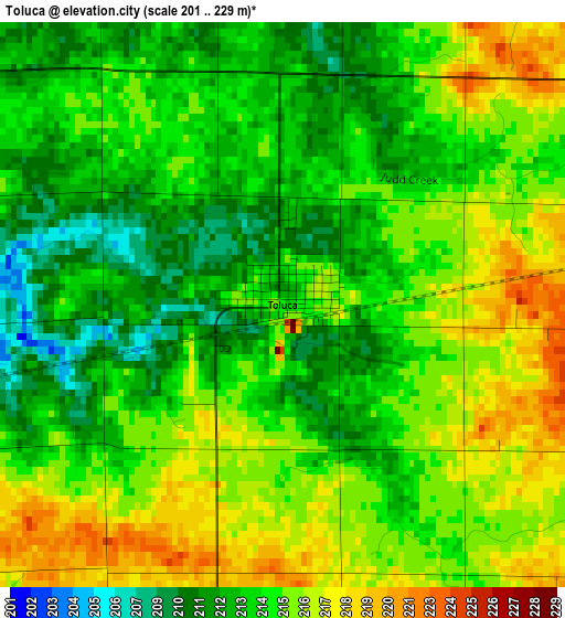
Below is the Elevation map of Toluca, which displays elevation range with different colors. Scale of the first map is from 201 to 229 m (659 to 751 ft) with average elevation of 214.3 meters (=703 ft) [note 1]
These maps also provides idea of topography and contour of this city, they are displayed at different zoom levels. More info about maps, scale and edge coordinates you can find below images.
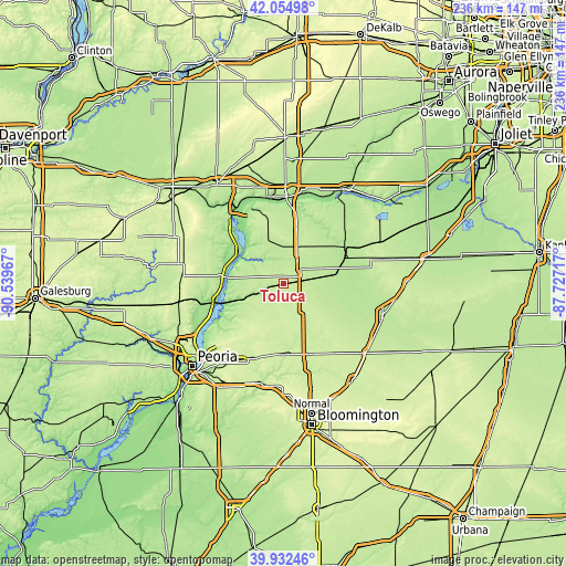
| \ | Map #1 | Topo.Map |
| Scale [m] | 201..229 m | × |
| Scale [ft] | 659..751 ft | × |
| Average | 214.3 m = 703 ft | × |
| Width | 7.38 km = 4.6 mi | 236 km = 146.6 mi |
| Height | 7.38 km = 4.6 mi | 236 km = 146.6 mi |
| ↑Max Latitude | 41.035416° | 42.05498° |
| Latitude at center | 41.00226° | 41.00226° |
| ↓Min Latitude | 40.969087° | 39.93246° |
| ← Min Longitude | -89.177365° | -90.53967° |
| Longitude center | -89.13342° | -89.13342° |
| →Max Longitude | -89.089475° | -87.72717° |
Nearby cities:
Cities around Toluca sort by population:
• Streator elevation 192 m
28.3 km,  62°
62°
• Chillicothe 154 m
30.9 km,  253°
253°
• Metamora 250 m
30.3 km,  219°
219°
• El Paso 230 m
30.9 km,  161°
161°
• Henry 151 m
22.3 km,  302°
302°
• Roanoke 221 m
23.5 km,  193°
193°
• Minonk 229 m
13.7 km,  142°
142°
• Lacon 146 m
23.4 km,  276°
276°
• Granville 211 m
29.8 km,  344°
344°
• Washburn 210 m
16.1 km,  235°
235°
• Flanagan 207 m
26.7 km,  121°
121°
• Hennepin 158 m
33 km,  328°
328°
Multilingual:
 En español:
Toluca elevación 212 m.
 En France:
Toluca élévation 212 m.


Sources and notes:
- [note 1] Map square and city borders are not equal. Map elevation data is calculated only from area inside that square.
- [src 1] Elevation data from geonames database provided with same terms of usage.
- [src 2] The elevation map of Toluca is generated using elevation data from NASA's 3 arcsec (90m) resolution SRTM data.
- [src 3] Base (background) map © OpenStreetMap contributors tiles are generated by Geofabrik and OpenTopoMap.
Copyright & License:
This Toluca Elevation Map is licensed under CC BY-SA. You may reuse any part from this page, if you give a proper credit by linking to this URL:
 More info on terms of use page.