Flanagan elevation
Flanagan (Illinois, Livingston County), United States elevation is 207 meters and Flanagan elevation in feet is 679 ft above sea level [src 1]. Flanagan is a populated place (feature code) with elevation that is 72 meters (236 ft) smaller than average city elevation in United States.
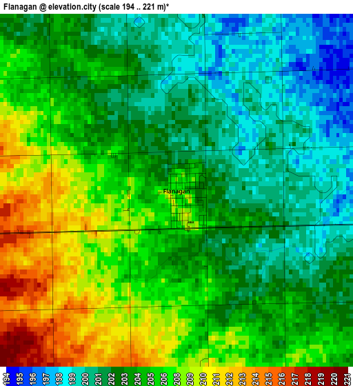
Below is the Elevation map of Flanagan, which displays elevation range with different colors. Scale of the first map is from 194 to 221 m (636 to 725 ft) with average elevation of 204.6 meters (=671 ft) [note 1]
These maps also provides idea of topography and contour of this city, they are displayed at different zoom levels. More info about maps, scale and edge coordinates you can find below images.
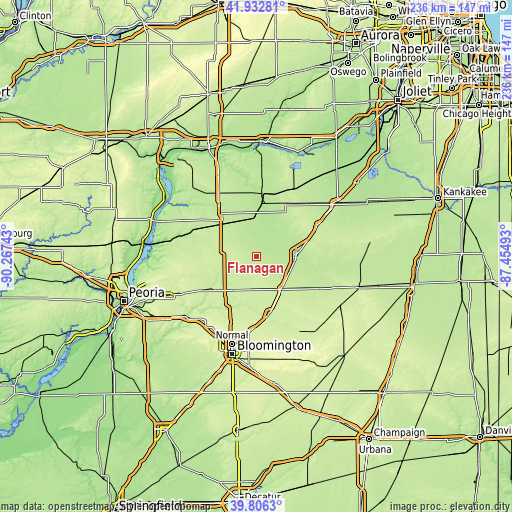
| \ | Map #1 | Topo.Map |
| Scale [m] | 194..221 m | × |
| Scale [ft] | 636..725 ft | × |
| Average | 204.6 m = 671 ft | × |
| Width | 7.39 km = 4.6 mi | 236.4 km = 146.9 mi |
| Height | 7.39 km = 4.6 mi | 236.4 km = 146.9 mi |
| ↑Max Latitude | 40.911309° | 41.93281° |
| Latitude at center | 40.87809° | 40.87809° |
| ↓Min Latitude | 40.844854° | 39.8063° |
| ← Min Longitude | -88.905125° | -90.26743° |
| Longitude center | -88.86118° | -88.86118° |
| →Max Longitude | -88.817235° | -87.45493° |
Nearby cities:
Cities around Flanagan sort by population:
• Streator elevation 192 m
27.1 km,  4°
4°
• Pontiac 200 m
19.5 km,  89°
89°
• Fairbury 215 m
32.6 km,  116°
116°
• El Paso 230 m
20.2 km,  220°
220°
• Roanoke 221 m
29.7 km,  252°
252°
• Lexington 232 m
27.1 km,  166°
166°
• Minonk 229 m
14.9 km,  281°
281°
• Hudson 238 m
32.1 km,  199°
199°
• Chenoa 222 m
19.3 km,  141°
141°
• Gridley 232 m
15.1 km,  186°
186°
• Toluca 212 m
26.7 km,  301°
301°
• Washburn 210 m
36.4 km, 277°
Multilingual:
 En español:
Flanagan elevación 207 m.
 En France:
Flanagan élévation 207 m.
 Auf Deutsch:
Flanagan höhe über dem Meeresspiegel ist 207 m.

Sources and notes:
- [note 1] Map square and city borders are not equal. Map elevation data is calculated only from area inside that square.
- [src 1] Elevation data from geonames database provided with same terms of usage.
- [src 2] The elevation map of Flanagan is generated using elevation data from NASA's 3 arcsec (90m) resolution SRTM data.
- [src 3] Base (background) map © OpenStreetMap contributors tiles are generated by Geofabrik and OpenTopoMap.
Copyright & License:
This Flanagan Elevation Map is licensed under CC BY-SA. You may reuse any part from this page, if you give a proper credit by linking to this URL:
 More info on terms of use page.