Princeville elevation
Princeville (Illinois, Peoria County), United States elevation is 228 meters and Princeville elevation in feet is 748 ft above sea level [src 1]. Princeville is a populated place (feature code) with elevation that is 51 meters (167 ft) smaller than average city elevation in United States.
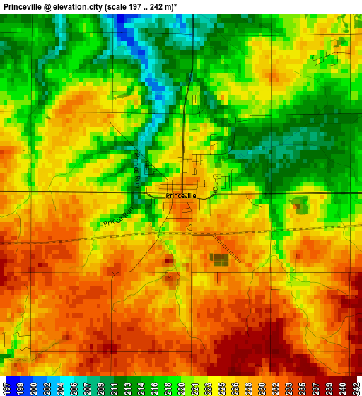
Below is the Elevation map of Princeville, which displays elevation range with different colors. Scale of the first map is from 197 to 242 m (646 to 794 ft) with average elevation of 223.5 meters (=733 ft) [note 1]
These maps also provides idea of topography and contour of this city, they are displayed at different zoom levels. More info about maps, scale and edge coordinates you can find below images.
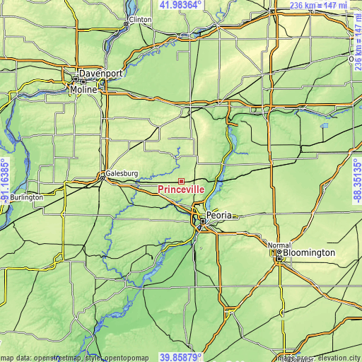
| \ | Map #1 | Topo.Map |
| Scale [m] | 197..242 m | × |
| Scale [ft] | 646..794 ft | × |
| Average | 223.5 m = 733 ft | × |
| Width | 7.38 km = 4.6 mi | 236.3 km = 146.8 mi |
| Height | 7.38 km = 4.6 mi | 236.3 km = 146.8 mi |
| ↑Max Latitude | 40.962953° | 41.98364° |
| Latitude at center | 40.92976° | 40.92976° |
| ↓Min Latitude | 40.89655° | 39.85879° |
| ← Min Longitude | -89.801545° | -91.16385° |
| Longitude center | -89.7576° | -89.7576° |
| →Max Longitude | -89.713655° | -88.35135° |
Nearby cities:
Cities around Princeville sort by population:
• Peoria elevation 165 m
29.8 km,  151°
151°
• North Peoria 194 m
27.7 km, 148°
• Chillicothe 154 m
22.8 km,  92°
92°
• Peoria Heights 245 m
25.5 km,  142°
142°
• West Peoria 185 m
28.5 km,  157°
157°
• Elmwood 195 m
24.4 km,  226°
226°
• Bellevue 206 m
28 km,  166°
166°
• Rome 142 m
22 km,  103°
103°
• Dunlap 225 m
10.1 km, 138°
• Wyoming 218 m
14.7 km,  354°
354°
• Toulon 225 m
20.3 km,  333°
333°
• Hanna City 223 m
26.7 km,  186°
186°
Multilingual:
 En español:
Princeville elevación 228 m.
 En France:
Princeville élévation 228 m.
 Auf Deutsch:
Princeville höhe über dem Meeresspiegel ist 228 m.

Sources and notes:
- [note 1] Map square and city borders are not equal. Map elevation data is calculated only from area inside that square.
- [src 1] Elevation data from geonames database provided with same terms of usage.
- [src 2] The elevation map of Princeville is generated using elevation data from NASA's 3 arcsec (90m) resolution SRTM data.
- [src 3] Base (background) map © OpenStreetMap contributors tiles are generated by Geofabrik and OpenTopoMap.
Copyright & License:
This Princeville Elevation Map is licensed under CC BY-SA. You may reuse any part from this page, if you give a proper credit by linking to this URL:
 More info on terms of use page.