Princeton elevation
Princeton (Illinois, Bureau County), United States elevation is 219 meters and Princeton elevation in feet is 719 ft above sea level [src 1]. Princeton is a seat of a second-order administrative division (feature code) with elevation that is 60 meters (197 ft) smaller than average city elevation in United States.
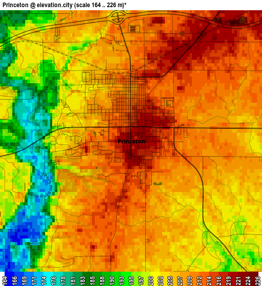
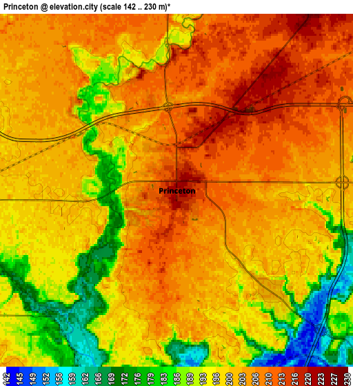
Below is the Elevation map of Princeton, which displays elevation range with different colors. Scale of the first map is from 164 to 226 m (538 to 741 ft) with average elevation of 204.7 meters (=672 ft) [note 1]
These maps also provides idea of topography and contour of this city, they are displayed at different zoom levels. More info about maps, scale and edge coordinates you can find below images.
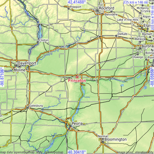
| \ | Map #1 | Map #2 | Topo.Map |
| Scale [m] | 164..226 m | 142..230 m | × |
| Scale [ft] | 538..741 ft | 466..755 ft | × |
| Average | 204.7 m = 672 ft | 199.6 m = 655 ft | × |
| Width | 7.33 km = 4.6 mi | 14.67 km = 9.1 mi | 234.7 km = 145.8 mi |
| Height | 7.33 km = 4.6 mi | 14.67 km = 9.1 mi | 234.7 km = 145.8 mi |
| ↑Max Latitude | 41.401062° | 41.434017° | 42.41488° |
| Latitude at center | 41.36809° | 41.36809° | 41.36809° |
| ↓Min Latitude | 41.335102° | 41.302096° | 40.30418° |
| ← Min Longitude | -89.508755° | -89.552701° | -90.87106° |
| Longitude center | -89.46481° | -89.46481° | -89.46481° |
| →Max Longitude | -89.420865° | -89.376919° | -88.05856° |
Nearby cities:
Cities around Princeton sort by population:
• Peru elevation 185 m
28.4 km,  99°
99°
• La Salle 175 m
31.4 km, 97°
• Mendota 229 m
35.1 km,  55°
55°
• Spring Valley 183 m
22.6 km, 101°
• Oglesby 194 m
34.8 km, 103°
• Deer Park 177 m
36.7 km, 102°
• Henry 151 m
29.9 km,  162°
162°
• Depue 145 m
14.1 km,  110°
110°
• Walnut 213 m
23.6 km,  332°
332°
• Granville 211 m
23.1 km,  120°
120°
• Ladd 200 m
20.6 km,  85°
85°
• Hennepin 158 m
16.3 km,  141°
141°
Multilingual:
 En español:
Princeton elevación 219 m.
 En France:
Princeton élévation 219 m.
 Auf Deutsch:
Princeton höhe über dem Meeresspiegel ist 219 m.

Sources and notes:
- [note 1] Map square and city borders are not equal. Map elevation data is calculated only from area inside that square.
- [src 1] Elevation data from geonames database provided with same terms of usage.
- [src 2] The elevation map of Princeton is generated using elevation data from NASA's 3 arcsec (90m) resolution SRTM data.
- [src 3] Base (background) map © OpenStreetMap contributors tiles are generated by Geofabrik and OpenTopoMap.
Copyright & License:
This Princeton Elevation Map is licensed under CC BY-SA. You may reuse any part from this page, if you give a proper credit by linking to this URL:
 More info on terms of use page.