Pecatonica elevation
Pecatonica (Illinois, Winnebago County), United States elevation is 233 meters and Pecatonica elevation in feet is 764 ft above sea level [src 1]. Pecatonica is a populated place (feature code) with elevation that is 46 meters (151 ft) smaller than average city elevation in United States.
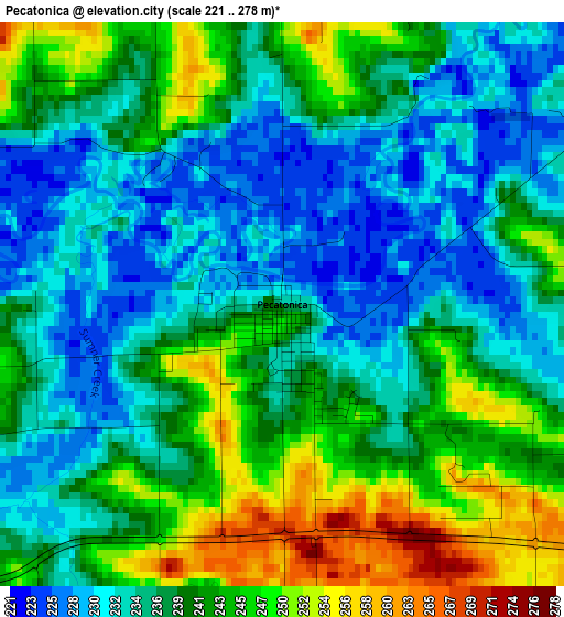
Below is the Elevation map of Pecatonica, which displays elevation range with different colors. Scale of the first map is from 221 to 278 m (725 to 912 ft) with average elevation of 238.6 meters (=783 ft) [note 1]
These maps also provides idea of topography and contour of this city, they are displayed at different zoom levels. More info about maps, scale and edge coordinates you can find below images.
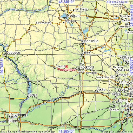
| \ | Map #1 | Topo.Map |
| Scale [m] | 221..278 m | × |
| Scale [ft] | 725..912 ft | × |
| Average | 238.6 m = 783 ft | × |
| Width | 7.23 km = 4.5 mi | 231.2 km = 143.7 mi |
| Height | 7.23 km = 4.5 mi | 231.2 km = 143.7 mi |
| ↑Max Latitude | 42.346398° | 43.34519° |
| Latitude at center | 42.31391° | 42.31391° |
| ↓Min Latitude | 42.281405° | 41.26545° |
| ← Min Longitude | -89.403225° | -90.76553° |
| Longitude center | -89.35928° | -89.35928° |
| →Max Longitude | -89.315335° | -87.95303° |
Nearby cities:
Cities around Pecatonica sort by population:
• Rockford elevation 224 m
22.3 km,  102°
102°
• Freeport 237 m
21.6 km,  264°
264°
• Loves Park 223 m
24.8 km,  88°
88°
• Machesney Park 228 m
26.6 km,  81°
81°
• Rockton 226 m
28.2 km,  56°
56°
• Byron 223 m
22.5 km,  157°
157°
• Winnebago 268 m
11.1 km,  118°
118°
• Mount Morris 281 m
29.9 km,  191°
191°
• Lake Summerset 260 m
15.8 km,  350°
350°
• Durand 237 m
13.8 km,  9°
9°
• Forreston 288 m
27.6 km,  220°
220°
• Stillman Valley 219 m
27.3 km,  147°
147°
Multilingual:
 En español:
Pecatonica elevación 233 m.
 En France:
Pecatonica élévation 233 m.
 Auf Deutsch:
Pecatonica höhe über dem Meeresspiegel ist 233 m.

Sources and notes:
- [note 1] Map square and city borders are not equal. Map elevation data is calculated only from area inside that square.
- [src 1] Elevation data from geonames database provided with same terms of usage.
- [src 2] The elevation map of Pecatonica is generated using elevation data from NASA's 3 arcsec (90m) resolution SRTM data.
- [src 3] Base (background) map © OpenStreetMap contributors tiles are generated by Geofabrik and OpenTopoMap.
Copyright & License:
This Pecatonica Elevation Map is licensed under CC BY-SA. You may reuse any part from this page, if you give a proper credit by linking to this URL:
 More info on terms of use page.