Durand elevation
Durand (Illinois, Winnebago County), United States elevation is 237 meters and Durand elevation in feet is 778 ft above sea level [src 1]. Durand is a populated place (feature code) with elevation that is 42 meters (138 ft) smaller than average city elevation in United States.
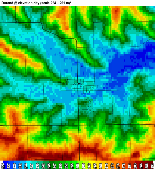
Below is the Elevation map of Durand, which displays elevation range with different colors. Scale of the first map is from 224 to 291 m (735 to 955 ft) with average elevation of 249.4 meters (=818 ft) [note 1]
These maps also provides idea of topography and contour of this city, they are displayed at different zoom levels. More info about maps, scale and edge coordinates you can find below images.
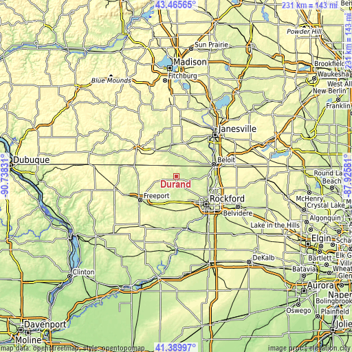
| \ | Map #1 | Topo.Map |
| Scale [m] | 224..291 m | × |
| Scale [ft] | 735..955 ft | × |
| Average | 249.4 m = 818 ft | × |
| Width | 7.21 km = 4.5 mi | 230.8 km = 143.4 mi |
| Height | 7.21 km = 4.5 mi | 230.8 km = 143.4 mi |
| ↑Max Latitude | 42.468824° | 43.46565° |
| Latitude at center | 42.4364° | 42.4364° |
| ↓Min Latitude | 42.403959° | 41.38997° |
| ← Min Longitude | -89.376005° | -90.73831° |
| Longitude center | -89.33206° | -89.33206° |
| →Max Longitude | -89.288115° | -87.92581° |
Nearby cities:
Cities around Durand sort by population:
• Beloit elevation 231 m
25.9 km,  72°
72°
• Loves Park 223 m
26 km,  119°
119°
• Machesney Park 228 m
26 km,  112°
112°
• Roscoe 228 m
26.6 km,  95°
95°
• South Beloit 225 m
25 km,  75°
75°
• Rockton 226 m
21.4 km,  85°
85°
• Brodhead 243 m
20.6 km,  349°
349°
• Winnebago 268 m
20.4 km,  158°
158°
• Pecatonica 233 m
13.8 km,  189°
189°
• Lake Summerset 260 m
5.1 km,  293°
293°
• Decatur 251 m
23 km,  343°
343°
• Orfordville 271 m
22.2 km,  16°
16°
Multilingual:
 En español:
Durand elevación 237 m.
 En France:
Durand élévation 237 m.


Sources and notes:
- [note 1] Map square and city borders are not equal. Map elevation data is calculated only from area inside that square.
- [src 1] Elevation data from geonames database provided with same terms of usage.
- [src 2] The elevation map of Durand is generated using elevation data from NASA's 3 arcsec (90m) resolution SRTM data.
- [src 3] Base (background) map © OpenStreetMap contributors tiles are generated by Geofabrik and OpenTopoMap.
Copyright & License:
This Durand Elevation Map is licensed under CC BY-SA. You may reuse any part from this page, if you give a proper credit by linking to this URL:
 More info on terms of use page.