Monticello elevation
Monticello (Illinois, Piatt County), United States elevation is 201 meters and Monticello elevation in feet is 659 ft above sea level [src 1]. Monticello is a seat of a second-order administrative division (feature code) with elevation that is 78 meters (256 ft) smaller than average city elevation in United States.
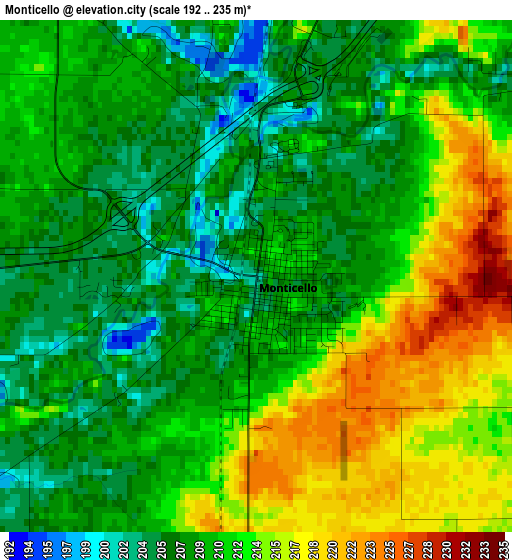
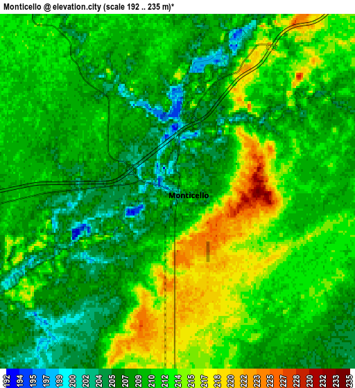
Below is the Elevation map of Monticello, which displays elevation range with different colors. Scale of the first map is from 192 to 235 m (630 to 771 ft) with average elevation of 210.4 meters (=690 ft) [note 1]
These maps also provides idea of topography and contour of this city, they are displayed at different zoom levels. More info about maps, scale and edge coordinates you can find below images.
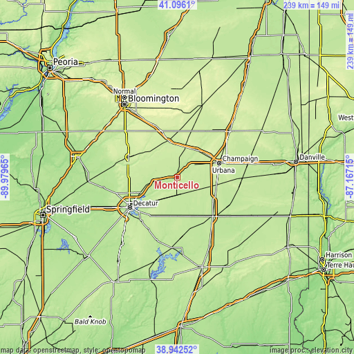
| \ | Map #1 | Map #2 | Topo.Map |
| Scale [m] | 192..235 m | 192..235 m | × |
| Scale [ft] | 630..771 ft | 630..771 ft | × |
| Average | 210.4 m = 690 ft | 210.3 m = 690 ft | × |
| Width | 7.48 km = 4.6 mi | 14.97 km = 9.3 mi | 239.5 km = 148.8 mi |
| Height | 7.48 km = 4.6 mi | 14.97 km = 9.3 mi | 239.5 km = 148.8 mi |
| ↑Max Latitude | 40.061452° | 40.095077° | 41.0961° |
| Latitude at center | 40.02781° | 40.02781° | 40.02781° |
| ↓Min Latitude | 39.994151° | 39.960476° | 38.94252° |
| ← Min Longitude | -88.617345° | -88.661291° | -89.97965° |
| Longitude center | -88.5734° | -88.5734° | -88.5734° |
| →Max Longitude | -88.529455° | -88.485509° | -87.16715° |
Nearby cities:
Cities around Monticello sort by population:
• Champaign elevation 228 m
29.8 km,  70°
70°
• Urbana 229 m
32.5 km, 73°
• Savoy 223 m
27.5 km,  83°
83°
• Mahomet 223 m
23.5 km,  37°
37°
• Tolono 224 m
27.2 km,  99°
99°
• Lake of the Woods 229 m
26.4 km, 41°
• Farmer City 221 m
24.7 km,  346°
346°
• Maroa 225 m
32.7 km,  271°
271°
• Bement 211 m
11.8 km,  179°
179°
• Cerro Gordo 230 m
20.2 km,  220°
220°
• Long Creek 209 m
33.5 km, 224°
• Atwood 205 m
27.1 km,  159°
159°
Multilingual:
 En español:
Monticello elevación 201 m.
 En France:
Monticello élévation 201 m.
 Auf Deutsch:
Monticello höhe über dem Meeresspiegel ist 201 m.

Sources and notes:
- [note 1] Map square and city borders are not equal. Map elevation data is calculated only from area inside that square.
- [src 1] Elevation data from geonames database provided with same terms of usage.
- [src 2] The elevation map of Monticello is generated using elevation data from NASA's 3 arcsec (90m) resolution SRTM data.
- [src 3] Base (background) map © OpenStreetMap contributors tiles are generated by Geofabrik and OpenTopoMap.
Copyright & License:
This Monticello Elevation Map is licensed under CC BY-SA. You may reuse any part from this page, if you give a proper credit by linking to this URL:
 More info on terms of use page.