Long Creek elevation
Long Creek (Illinois, Macon County), United States elevation is 209 meters and Long Creek elevation in feet is 686 ft above sea level [src 1]. Long Creek is a populated place (feature code) with elevation that is 70 meters (230 ft) smaller than average city elevation in United States.
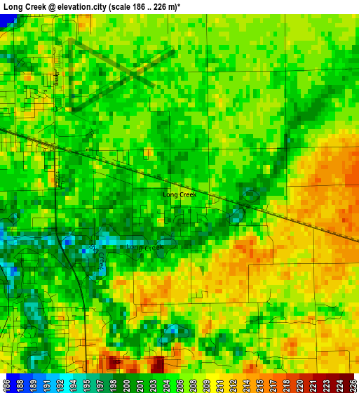
Below is the Elevation map of Long Creek, which displays elevation range with different colors. Scale of the first map is from 186 to 226 m (610 to 741 ft) with average elevation of 206.2 meters (=677 ft) [note 1]
These maps also provides idea of topography and contour of this city, they are displayed at different zoom levels. More info about maps, scale and edge coordinates you can find below images.
| \ | Map #1 | Topo.Map |
| Scale [m] | 186..226 m | × |
| Scale [ft] | 610..741 ft | × |
| Average | 206.2 m = 677 ft | × |
| Width | 7.51 km = 4.7 mi | 240.2 km = 149.3 mi |
| Height | 7.51 km = 4.7 mi | 240.2 km = 149.3 mi |
| ↑Max Latitude | 39.845728° | 40.88368° |
| Latitude at center | 39.81198° | 39.81198° |
| ↓Min Latitude | 39.778215° | 38.7233° |
| ← Min Longitude | -88.891515° | -90.25382° |
| Longitude center | -88.84757° | -88.84757° |
| →Max Longitude | -88.803625° | -87.44132° |
Nearby cities:
Cities around Long Creek sort by population:
• Decatur elevation 206 m
9.7 km,  288°
288°
• Mount Zion 217 m
5.1 km,  206°
206°
• Forsyth 212 m
16.1 km,  326°
326°
• Moweaqua 195 m
25.5 km,  215°
215°
• Bement 211 m
26.5 km,  62°
62°
• Cerro Gordo 230 m
13.4 km,  49°
49°
• Harristown 213 m
20.7 km,  283°
283°
• Bethany 202 m
20.7 km,  153°
153°
• Warrensburg 217 m
22.7 km,  306°
306°
• Macon 215 m
16.9 km,  229°
229°
• Blue Mound 193 m
26.6 km,  242°
242°
• Lovington 207 m
21.3 km,  120°
120°
Multilingual:
 En español:
Long Creek elevación 209 m.
 En France:
Long Creek élévation 209 m.
 Auf Deutsch:
Long Creek höhe über dem Meeresspiegel ist 209 m.

Sources and notes:
- [note 1] Map square and city borders are not equal. Map elevation data is calculated only from area inside that square.
- [src 1] Elevation data from geonames database provided with same terms of usage.
- [src 2] The elevation map of Long Creek is generated using elevation data from NASA's 3 arcsec (90m) resolution SRTM data.
- [src 3] Base (background) map © OpenStreetMap contributors tiles are generated by Geofabrik and OpenTopoMap.
Copyright & License:
This Long Creek Elevation Map is licensed under CC BY-SA. You may reuse any part from this page, if you give a proper credit by linking to this URL:
 More info on terms of use page.