Hillcrest elevation
Hillcrest (Illinois, Ogle County), United States elevation is 251 meters and Hillcrest elevation in feet is 823 ft above sea level [src 1]. Hillcrest is a populated place (feature code) with elevation that is 28 meters (92 ft) smaller than average city elevation in United States.
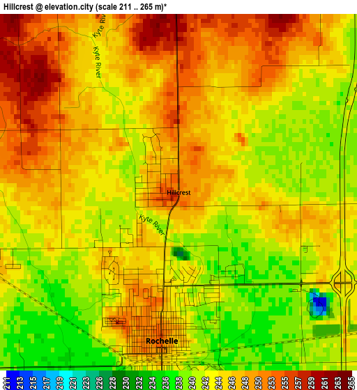
Below is the Elevation map of Hillcrest, which displays elevation range with different colors. Scale of the first map is from 211 to 265 m (692 to 869 ft) with average elevation of 245.2 meters (=804 ft) [note 1]
These maps also provides idea of topography and contour of this city, they are displayed at different zoom levels. More info about maps, scale and edge coordinates you can find below images.
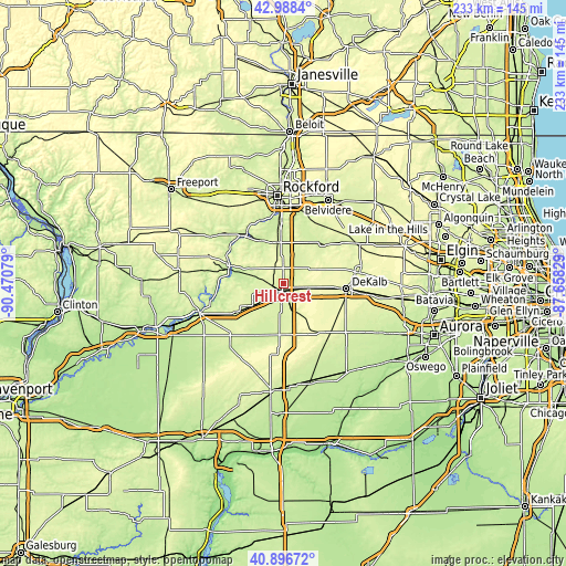
| \ | Map #1 | Topo.Map |
| Scale [m] | 211..265 m | × |
| Scale [ft] | 692..869 ft | × |
| Average | 245.2 m = 804 ft | × |
| Width | 7.27 km = 4.5 mi | 232.6 km = 144.5 mi |
| Height | 7.27 km = 4.5 mi | 232.6 km = 144.5 mi |
| ↑Max Latitude | 41.983814° | 42.9884° |
| Latitude at center | 41.95114° | 41.95114° |
| ↓Min Latitude | 41.918449° | 40.89672° |
| ← Min Longitude | -89.108485° | -90.47079° |
| Longitude center | -89.06454° | -89.06454° |
| →Max Longitude | -89.020595° | -87.65829° |
Nearby cities:
Cities around Hillcrest sort by population:
• DeKalb elevation 270 m
26.1 km,  95°
95°
• Rochelle 251 m
3 km,  186°
186°
• Cortland 277 m
31.3 km, 96°
• Byron 223 m
25.1 km,  321°
321°
• Oregon 218 m
23.2 km,  287°
287°
• Carthage 244 m
20.9 km,  260°
260°
• Davis Junction 246 m
16.9 km,  351°
351°
• Kirkland 235 m
23.6 km,  48°
48°
• Waterman 256 m
31.3 km,  129°
129°
• Kingston 240 m
30.2 km,  56°
56°
• Malta 280 m
17 km, 98°
• Stillman Valley 219 m
19.8 km,  331°
331°
Multilingual:
 En español:
Hillcrest elevación 251 m.
 En France:
Hillcrest élévation 251 m.
 Auf Deutsch:
Hillcrest höhe über dem Meeresspiegel ist 251 m.

Sources and notes:
- [note 1] Map square and city borders are not equal. Map elevation data is calculated only from area inside that square.
- [src 1] Elevation data from geonames database provided with same terms of usage.
- [src 2] The elevation map of Hillcrest is generated using elevation data from NASA's 3 arcsec (90m) resolution SRTM data.
- [src 3] Base (background) map © OpenStreetMap contributors tiles are generated by Geofabrik and OpenTopoMap.
Copyright & License:
This Hillcrest Elevation Map is licensed under CC BY-SA. You may reuse any part from this page, if you give a proper credit by linking to this URL:
 More info on terms of use page.