Solon elevation
Solon (Iowa, Johnson County), United States elevation is 244 meters and Solon elevation in feet is 801 ft above sea level [src 1]. Solon is a populated place (feature code) with elevation that is 35 meters (115 ft) smaller than average city elevation in United States.
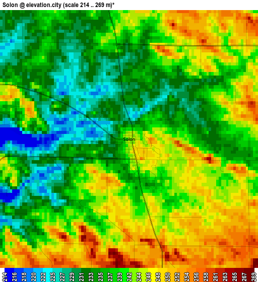
Below is the Elevation map of Solon, which displays elevation range with different colors. Scale of the first map is from 214 to 269 m (702 to 883 ft) with average elevation of 239.6 meters (=786 ft) [note 1]
These maps also provides idea of topography and contour of this city, they are displayed at different zoom levels. More info about maps, scale and edge coordinates you can find below images.
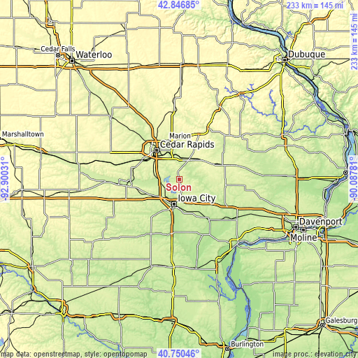
| \ | Map #1 | Topo.Map |
| Scale [m] | 214..269 m | × |
| Scale [ft] | 702..883 ft | × |
| Average | 239.6 m = 786 ft | × |
| Width | 7.28 km = 4.5 mi | 233.1 km = 144.8 mi |
| Height | 7.28 km = 4.5 mi | 233.1 km = 144.8 mi |
| ↑Max Latitude | 41.839978° | 42.84685° |
| Latitude at center | 41.80723° | 41.80723° |
| ↓Min Latitude | 41.774465° | 40.75046° |
| ← Min Longitude | -91.538005° | -92.90031° |
| Longitude center | -91.49406° | -91.49406° |
| →Max Longitude | -91.450115° | -90.08781° |
Nearby cities:
Cities around Solon sort by population:
• Cedar Rapids elevation 251 m
25.6 km,  330°
330°
• Iowa City 204 m
16.5 km,  190°
190°
• Marion 262 m
26.6 km,  341°
341°
• Coralville 208 m
16.2 km,  206°
206°
• North Liberty 236 m
10.8 km,  233°
233°
• Mount Vernon 268 m
14.3 km,  26°
26°
• Tiffin 218 m
18 km, 231°
• West Branch 222 m
19.4 km,  140°
140°
• Lisbon 265 m
15.5 km,  35°
35°
• Ely 225 m
10.6 km,  314°
314°
• University Heights 239 m
17.7 km,  197°
197°
• Mechanicsville 279 m
22.6 km,  61°
61°
Multilingual:
 En español:
Solon elevación 244 m.
 En France:
Solon élévation 244 m.


Sources and notes:
- [note 1] Map square and city borders are not equal. Map elevation data is calculated only from area inside that square.
- [src 1] Elevation data from geonames database provided with same terms of usage.
- [src 2] The elevation map of Solon is generated using elevation data from NASA's 3 arcsec (90m) resolution SRTM data.
- [src 3] Base (background) map © OpenStreetMap contributors tiles are generated by Geofabrik and OpenTopoMap.
Copyright & License:
This Solon Elevation Map is licensed under CC BY-SA. You may reuse any part from this page, if you give a proper credit by linking to this URL:
 More info on terms of use page.