Sheffield elevation
Sheffield (Iowa, Franklin County), United States elevation is 328 meters and Sheffield elevation in feet is 1076 ft above sea level [src 1]. Sheffield is a populated place (feature code) with elevation that is 49 meters (161 ft) bigger than average city elevation in United States.
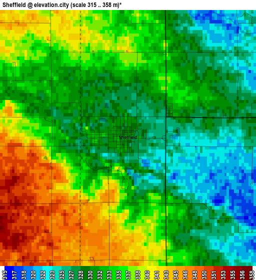
Below is the Elevation map of Sheffield, which displays elevation range with different colors. Scale of the first map is from 315 to 358 m (1033 to 1175 ft) with average elevation of 333.4 meters (=1094 ft) [note 1]
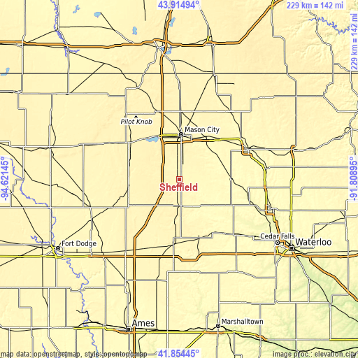
These maps also provides idea of topography and contour of this city, they are displayed at different zoom levels. More info about maps, scale and edge coordinates you can find below images.
| \ | Map #1 | Topo.Map |
| Scale [m] | 315..358 m | × |
| Scale [ft] | 1033..1175 ft | × |
| Average | 333.4 m = 1094 ft | × |
| Width | 7.16 km = 4.4 mi | 229.1 km = 142.4 mi |
| Height | 7.16 km = 4.4 mi | 229.1 km = 142.4 mi |
| ↑Max Latitude | 42.925487° | 43.91494° |
| Latitude at center | 42.8933° | 42.8933° |
| ↓Min Latitude | 42.861096° | 41.85445° |
| ← Min Longitude | -93.259145° | -94.62145° |
| Longitude center | -93.2152° | -93.2152° |
| →Max Longitude | -93.171255° | -91.80895° |
Nearby cities:
Cities around Sheffield sort by population:
• Mason City elevation 348 m
29 km,  2°
2°
• Clear Lake 376 m
30.3 km,  333°
333°
• Iowa Falls 342 m
41.3 km,  184°
184°
• Hampton 350 m
16.9 km, 176°
• Garner 368 m
39.1 km,  306°
306°
• Belmond 360 m
32.9 km,  260°
260°
• Ackley 335 m
40 km,  160°
160°
• Oakland 344 m
39.4 km,  208°
208°
• Nora Springs 333 m
32.6 km,  31°
31°
• Greene 292 m
33.6 km,  89°
89°
• Allison 320 m
37.6 km,  114°
114°
• Rockwell 339 m
10.4 km,  10°
10°
Multilingual:
 En español:
Sheffield elevación 328 m.
 En France:
Sheffield élévation 328 m.
 Auf Deutsch:
Sheffield höhe über dem Meeresspiegel ist 328 m.

Sources and notes:
- [note 1] Map square and city borders are not equal. Map elevation data is calculated only from area inside that square.
- [src 1] Elevation data from geonames database provided with same terms of usage.
- [src 2] The elevation map of Sheffield is generated using elevation data from NASA's 3 arcsec (90m) resolution SRTM data.
- [src 3] Base (background) map © OpenStreetMap contributors tiles are generated by Geofabrik and OpenTopoMap.
Copyright & License:
This Sheffield Elevation Map is licensed under CC BY-SA. You may reuse any part from this page, if you give a proper credit by linking to this URL:
 More info on terms of use page.