Nashua elevation
Nashua (Iowa, Chickasaw County), United States elevation is 301 meters and Nashua elevation in feet is 988 ft above sea level [src 1]. Nashua is a populated place (feature code) with elevation that is 22 meters (72 ft) bigger than average city elevation in United States.
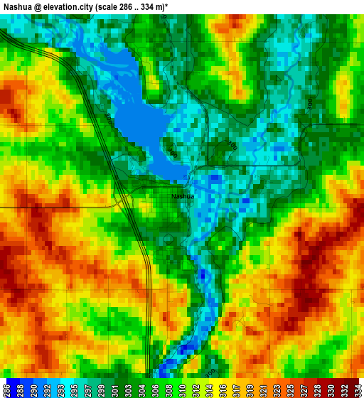
Below is the Elevation map of Nashua, which displays elevation range with different colors. Scale of the first map is from 286 to 334 m (938 to 1096 ft) with average elevation of 308.8 meters (=1013 ft) [note 1]
These maps also provides idea of topography and contour of this city, they are displayed at different zoom levels. More info about maps, scale and edge coordinates you can find below images.
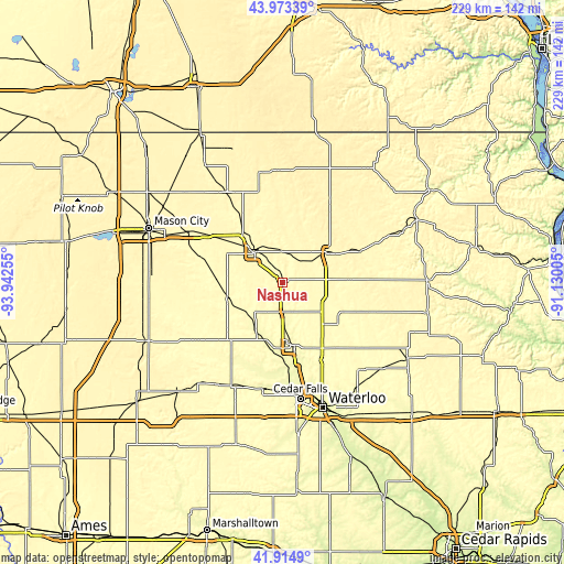
| \ | Map #1 | Topo.Map |
| Scale [m] | 286..334 m | × |
| Scale [ft] | 938..1096 ft | × |
| Average | 308.8 m = 1013 ft | × |
| Width | 7.15 km = 4.4 mi | 228.9 km = 142.2 mi |
| Height | 7.15 km = 4.4 mi | 228.9 km = 142.2 mi |
| ↑Max Latitude | 42.984906° | 43.97339° |
| Latitude at center | 42.95275° | 42.95275° |
| ↓Min Latitude | 42.920577° | 41.9149° |
| ← Min Longitude | -92.580245° | -93.94255° |
| Longitude center | -92.5363° | -92.5363° |
| →Max Longitude | -92.492355° | -91.13005° |
Nearby cities:
Cities around Nashua sort by population:
• Waverly elevation 281 m
25.7 km,  168°
168°
• Charles City 307 m
16.8 km,  318°
318°
• Osage 361 m
43.1 km,  328°
328°
• New Hampton 356 m
21.4 km,  56°
56°
• Sumner 324 m
38.1 km,  107°
107°
• Denver 286 m
35.2 km,  152°
152°
• Clarksville 291 m
21.5 km,  209°
209°
• Nora Springs 333 m
43.5 km,  299°
299°
• Tripoli 316 m
27.8 km,  125°
125°
• Shell Rock 282 m
27.2 km,  188°
188°
• Greene 292 m
22.6 km,  253°
253°
• Allison 320 m
30.7 km,  223°
223°
Multilingual:
 En español:
Nashua elevación 301 m.
 En France:
Nashua élévation 301 m.


Sources and notes:
- [note 1] Map square and city borders are not equal. Map elevation data is calculated only from area inside that square.
- [src 1] Elevation data from geonames database provided with same terms of usage.
- [src 2] The elevation map of Nashua is generated using elevation data from NASA's 3 arcsec (90m) resolution SRTM data.
- [src 3] Base (background) map © OpenStreetMap contributors tiles are generated by Geofabrik and OpenTopoMap.
Copyright & License:
This Nashua Elevation Map is licensed under CC BY-SA. You may reuse any part from this page, if you give a proper credit by linking to this URL:
 More info on terms of use page.