Milford elevation
Milford (Iowa, Dickinson County), United States elevation is 437 meters and Milford elevation in feet is 1434 ft above sea level [src 1]. Milford is a populated place (feature code) with elevation that is 158 meters (518 ft) bigger than average city elevation in United States.
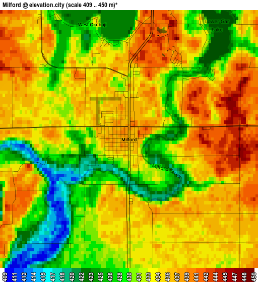
Below is the Elevation map of Milford, which displays elevation range with different colors. Scale of the first map is from 409 to 450 m (1342 to 1476 ft) with average elevation of 432.8 meters (=1420 ft) [note 1]
These maps also provides idea of topography and contour of this city, they are displayed at different zoom levels. More info about maps, scale and edge coordinates you can find below images.
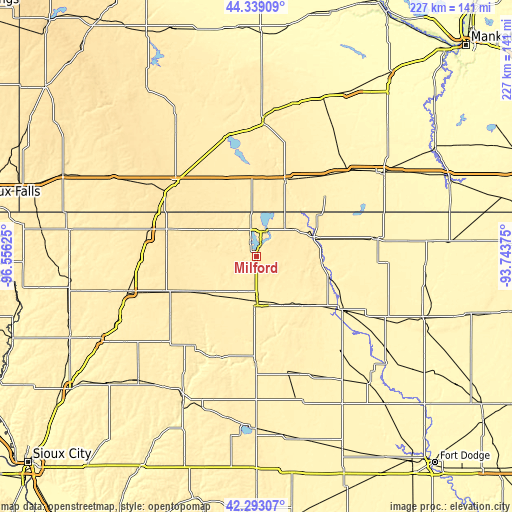
| \ | Map #1 | Topo.Map |
| Scale [m] | 409..450 m | × |
| Scale [ft] | 1342..1476 ft | × |
| Average | 432.8 m = 1420 ft | × |
| Width | 7.11 km = 4.4 mi | 227.5 km = 141.4 mi |
| Height | 7.11 km = 4.4 mi | 227.5 km = 141.4 mi |
| ↑Max Latitude | 43.356651° | 44.33909° |
| Latitude at center | 43.32469° | 43.32469° |
| ↓Min Latitude | 43.292712° | 42.29307° |
| ← Min Longitude | -95.193945° | -96.55625° |
| Longitude center | -95.15° | -95.15° |
| →Max Longitude | -95.106055° | -93.74375° |
Nearby cities:
Cities around Milford sort by population:
• Worthington elevation 486 m
48.7 km,  312°
312°
• Spencer 402 m
20.4 km,  178°
178°
• Estherville 395 m
27 km,  71°
71°
• Spirit Lake 451 m
11.5 km,  19°
19°
• Emmetsburg 378 m
44.6 km,  121°
121°
• Jackson 396 m
35.4 km, 21°
• Lakefield 451 m
39.3 km,  357°
357°
• Hartley 444 m
31 km,  238°
238°
• Sanborn 469 m
43.9 km,  248°
248°
• Arnolds Park 437 m
5.7 km, 21°
• Lake Park 451 m
20.1 km,  316°
316°
• Primghar 463 m
46.8 km, 235°
Multilingual:
 En español:
Milford elevación 437 m.
 En France:
Milford élévation 437 m.


Sources and notes:
- [note 1] Map square and city borders are not equal. Map elevation data is calculated only from area inside that square.
- [src 1] Elevation data from geonames database provided with same terms of usage.
- [src 2] The elevation map of Milford is generated using elevation data from NASA's 3 arcsec (90m) resolution SRTM data.
- [src 3] Base (background) map © OpenStreetMap contributors tiles are generated by Geofabrik and OpenTopoMap.
Copyright & License:
This Milford Elevation Map is licensed under CC BY-SA. You may reuse any part from this page, if you give a proper credit by linking to this URL:
 More info on terms of use page.