Laurens elevation
Laurens (Iowa, Pocahontas County), United States elevation is 396 meters and Laurens elevation in feet is 1299 ft above sea level [src 1]. Laurens is a populated place (feature code) with elevation that is 117 meters (384 ft) bigger than average city elevation in United States.
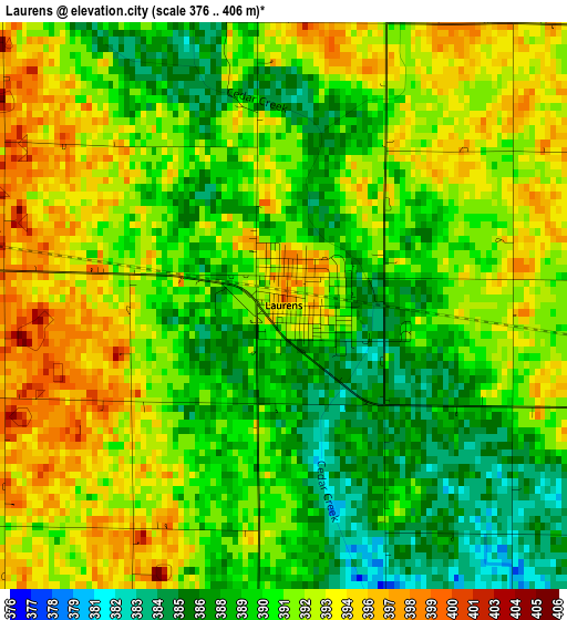
Below is the Elevation map of Laurens, which displays elevation range with different colors. Scale of the first map is from 376 to 406 m (1234 to 1332 ft) with average elevation of 390.9 meters (=1282 ft) [note 1]
These maps also provides idea of topography and contour of this city, they are displayed at different zoom levels. More info about maps, scale and edge coordinates you can find below images.
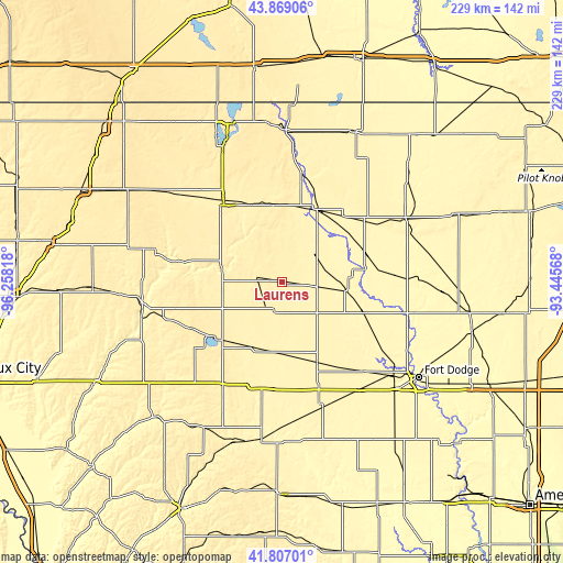
| \ | Map #1 | Topo.Map |
| Scale [m] | 376..406 m | × |
| Scale [ft] | 1234..1332 ft | × |
| Average | 390.9 m = 1282 ft | × |
| Width | 7.16 km = 4.4 mi | 229.3 km = 142.5 mi |
| Height | 7.16 km = 4.4 mi | 229.3 km = 142.5 mi |
| ↑Max Latitude | 42.878851° | 43.86906° |
| Latitude at center | 42.84664° | 42.84664° |
| ↓Min Latitude | 42.814412° | 41.80701° |
| ← Min Longitude | -94.895875° | -96.25818° |
| Longitude center | -94.85193° | -94.85193° |
| →Max Longitude | -94.807985° | -93.44568° |
Nearby cities:
Cities around Laurens sort by population:
• Spencer elevation 402 m
40.5 km,  324°
324°
• Storm Lake 431 m
37.1 km,  231°
231°
• Algona 363 m
56.2 km,  63°
63°
• Cherokee 361 m
58.1 km,  259°
259°
• Humboldt 331 m
53.8 km,  105°
105°
• Emmetsburg 378 m
32.6 km,  24°
24°
• Sac City 367 m
48.5 km,  193°
193°
• Rockwell City 372 m
53.3 km,  160°
160°
• Alta 454 m
40.6 km,  241°
241°
• Pocahontas 374 m
19.4 km,  129°
129°
• Manson 374 m
43.8 km,  143°
143°
• Dakota City 341 m
55.2 km,  104°
104°
Multilingual:
 En español:
Laurens elevación 396 m.
 En France:
Laurens élévation 396 m.


Sources and notes:
- [note 1] Map square and city borders are not equal. Map elevation data is calculated only from area inside that square.
- [src 1] Elevation data from geonames database provided with same terms of usage.
- [src 2] The elevation map of Laurens is generated using elevation data from NASA's 3 arcsec (90m) resolution SRTM data.
- [src 3] Base (background) map © OpenStreetMap contributors tiles are generated by Geofabrik and OpenTopoMap.
Copyright & License:
This Laurens Elevation Map is licensed under CC BY-SA. You may reuse any part from this page, if you give a proper credit by linking to this URL:
 More info on terms of use page.