Cherokee elevation
Cherokee (Iowa, Cherokee County), United States elevation is 361 meters and Cherokee elevation in feet is 1184 ft above sea level [src 1]. Cherokee is a seat of a second-order administrative division (feature code) with elevation that is 82 meters (269 ft) bigger than average city elevation in United States.
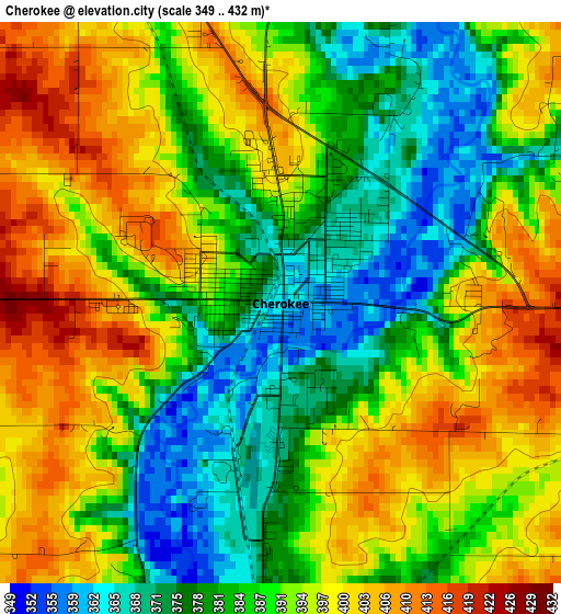
Below is the Elevation map of Cherokee, which displays elevation range with different colors. Scale of the first map is from 349 to 432 m (1145 to 1417 ft) with average elevation of 389.2 meters (=1277 ft) [note 1]
These maps also provides idea of topography and contour of this city, they are displayed at different zoom levels. More info about maps, scale and edge coordinates you can find below images.
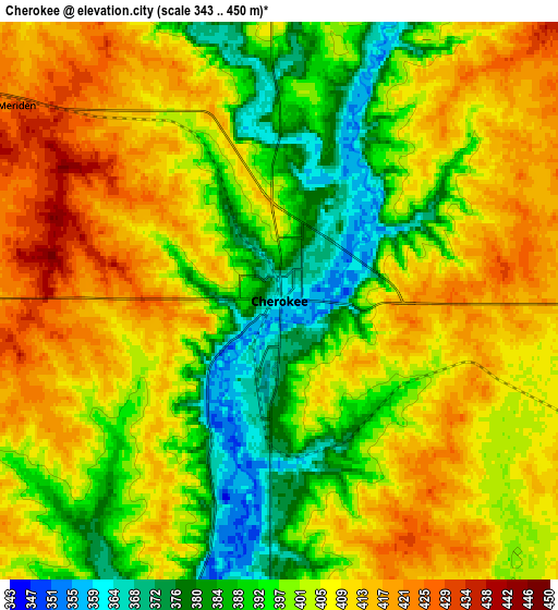
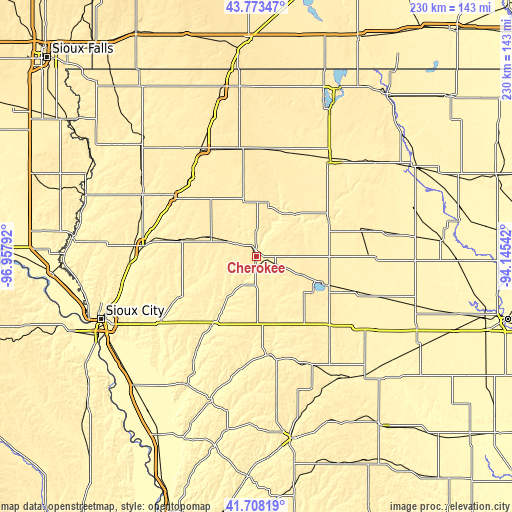
| \ | Map #1 | Map #2 | Topo.Map |
| Scale [m] | 349..432 m | 343..450 m | × |
| Scale [ft] | 1145..1417 ft | 1125..1476 ft | × |
| Average | 389.2 m = 1277 ft | 402 m = 1319 ft | × |
| Width | 7.18 km = 4.5 mi | 14.35 km = 8.9 mi | 229.6 km = 142.7 mi |
| Height | 7.18 km = 4.5 mi | 14.35 km = 8.9 mi | 229.6 km = 142.7 mi |
| ↑Max Latitude | 42.781692° | 42.813937° | 43.77347° |
| Latitude at center | 42.74943° | 42.74943° | 42.74943° |
| ↓Min Latitude | 42.717151° | 42.684856° | 41.70819° |
| ← Min Longitude | -95.595615° | -95.639561° | -96.95792° |
| Longitude center | -95.55167° | -95.55167° | -95.55167° |
| →Max Longitude | -95.507725° | -95.463779° | -94.14542° |
Nearby cities:
Cities around Cherokee sort by population:
• Storm Lake elevation 431 m
30.4 km,  113°
113°
• Ida Grove 376 m
45.4 km,  171°
171°
• Alta 454 m
22.9 km, 111°
• Remsen 404 m
35.2 km,  281°
281°
• Hartley 444 m
48.3 km,  7°
7°
• Kingsley 382 m
38.4 km,  242°
242°
• Holstein 443 m
28.9 km,  178°
178°
• Sanborn 469 m
48.8 km,  350°
350°
• Alton 404 m
45.8 km,  305°
305°
• Marcus 445 m
22.5 km,  292°
292°
• Paullina 424 m
27.9 km,  336°
336°
• Primghar 463 m
38 km, 350°
Multilingual:
 En español:
Cherokee elevación 361 m.
 En France:
Cherokee élévation 361 m.
 Auf Deutsch:
Cherokee höhe über dem Meeresspiegel ist 361 m.

Sources and notes:
- [note 1] Map square and city borders are not equal. Map elevation data is calculated only from area inside that square.
- [src 1] Elevation data from geonames database provided with same terms of usage.
- [src 2] The elevation map of Cherokee is generated using elevation data from NASA's 3 arcsec (90m) resolution SRTM data.
- [src 3] Base (background) map © OpenStreetMap contributors tiles are generated by Geofabrik and OpenTopoMap.
Copyright & License:
This Cherokee Elevation Map is licensed under CC BY-SA. You may reuse any part from this page, if you give a proper credit by linking to this URL:
 More info on terms of use page.