Alton elevation
Alton (Iowa, Sioux County), United States elevation is 404 meters and Alton elevation in feet is 1325 ft above sea level [src 1]. Alton is a populated place (feature code) with elevation that is 125 meters (410 ft) bigger than average city elevation in United States.
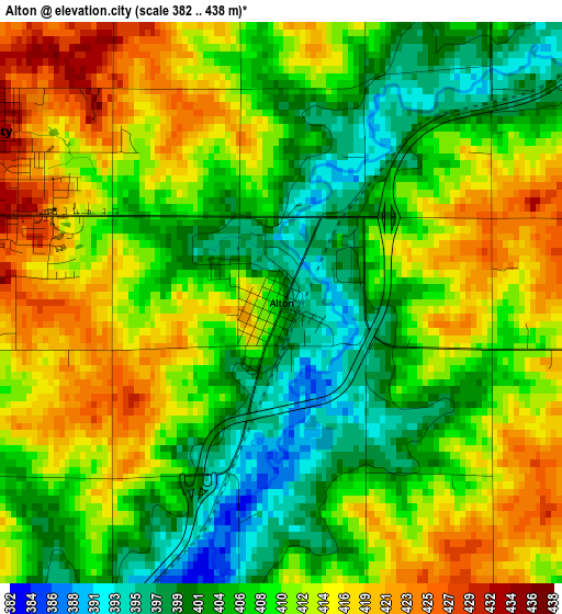
Below is the Elevation map of Alton, which displays elevation range with different colors. Scale of the first map is from 382 to 438 m (1253 to 1437 ft) with average elevation of 409.5 meters (=1344 ft) [note 1]
These maps also provides idea of topography and contour of this city, they are displayed at different zoom levels. More info about maps, scale and edge coordinates you can find below images.
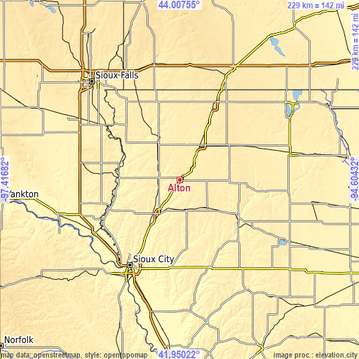
| \ | Map #1 | Topo.Map |
| Scale [m] | 382..438 m | × |
| Scale [ft] | 1253..1437 ft | × |
| Average | 409.5 m = 1344 ft | × |
| Width | 7.15 km = 4.4 mi | 228.8 km = 142.2 mi |
| Height | 7.15 km = 4.4 mi | 228.7 km = 142.1 mi |
| ↑Max Latitude | 43.019628° | 44.00755° |
| Latitude at center | 42.98749° | 42.98749° |
| ↓Min Latitude | 42.955335° | 41.95022° |
| ← Min Longitude | -96.054515° | -97.41682° |
| Longitude center | -96.01057° | -96.01057° |
| →Max Longitude | -95.966625° | -94.60432° |
Nearby cities:
Cities around Alton sort by population:
• Le Mars elevation 374 m
24.9 km,  210°
210°
• Sioux Center 444 m
16.9 km,  307°
307°
• Orange City 436 m
4.5 km,  299°
299°
• Sheldon 432 m
24.9 km,  30°
30°
• Rock Valley 380 m
33.5 km,  316°
316°
• Hawarden 360 m
38.6 km,  271°
271°
• Hull 437 m
24.5 km,  335°
335°
• Remsen 404 m
19.4 km,  171°
171°
• Sanborn 469 m
36 km,  53°
53°
• Marcus 445 m
24.4 km,  137°
137°
• Paullina 424 m
26.2 km,  92°
92°
• Primghar 463 m
33.1 km,  70°
70°
Multilingual:
 En español:
Alton elevación 404 m.
 En France:
Alton élévation 404 m.


Sources and notes:
- [note 1] Map square and city borders are not equal. Map elevation data is calculated only from area inside that square.
- [src 1] Elevation data from geonames database provided with same terms of usage.
- [src 2] The elevation map of Alton is generated using elevation data from NASA's 3 arcsec (90m) resolution SRTM data.
- [src 3] Base (background) map © OpenStreetMap contributors tiles are generated by Geofabrik and OpenTopoMap.
Copyright & License:
This Alton Elevation Map is licensed under CC BY-SA. You may reuse any part from this page, if you give a proper credit by linking to this URL:
 More info on terms of use page.