Shelton elevation
Shelton (Connecticut, Fairfield County), United States elevation is 13 meters and Shelton elevation in feet is 43 ft above sea level [src 1]. Shelton is a populated place (feature code) with elevation that is 266 meters (873 ft) smaller than average city elevation in United States.
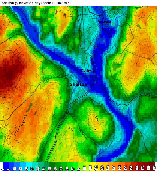
Below is the Elevation map of Shelton, which displays elevation range with different colors. Scale of the first map is from 1 to 187 m (3 to 614 ft) with average elevation of 81.1 meters (=266 ft) [note 1]
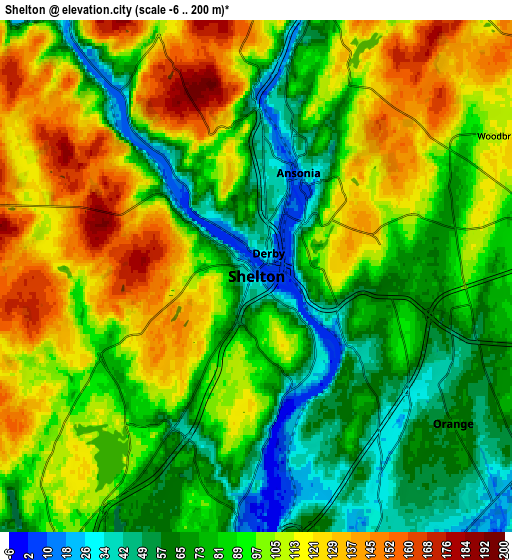
These maps also provides idea of topography and contour of this city, they are displayed at different zoom levels. More info about maps, scale and edge coordinates you can find below images.
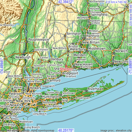
| \ | Map #1 | Map #2 | Topo.Map |
| Scale [m] | 1..187 m | -6..200 m | × |
| Scale [ft] | 3..614 ft | -20..656 ft | × |
| Average | 81.1 m = 266 ft | 92.3 m = 303 ft | × |
| Width | 7.34 km = 4.6 mi | 14.68 km = 9.1 mi | 234.9 km = 146 mi |
| Height | 7.34 km = 4.6 mi | 14.68 km = 9.1 mi | 234.9 km = 146 mi |
| ↑Max Latitude | 41.349488° | 41.382469° | 42.36412° |
| Latitude at center | 41.31649° | 41.31649° | 41.31649° |
| ↓Min Latitude | 41.283475° | 41.250444° | 40.25175° |
| ← Min Longitude | -73.137105° | -73.181051° | -74.49941° |
| Longitude center | -73.09316° | -73.09316° | -73.09316° |
| →Max Longitude | -73.049215° | -73.005269° | -71.68691° |
Nearby cities:
Cities around Shelton sort by population:
• New Haven elevation 20 m
13.8 km,  93°
93°
• West Haven 5 m
13.2 km,  112°
112°
• Milford 13 m
10.9 km,  163°
163°
• City of Milford (balance) 19 m
10.6 km,  165°
165°
• Trumbull 75 m
12.2 km,  227°
227°
• Ansonia 19 m
3.5 km,  19°
19°
• Seymour 30 m
9 km,  9°
9°
• Orange 69 m
7.1 km,  126°
126°
• Derby 25 m
0.6 km,  36°
36°
• Oxford 110 m
13.2 km,  351°
351°
• Woodbridge 114 m
8.1 km,  60°
60°
• Woodmont 15 m
13 km,  139°
139°
Multilingual:
 En español:
Shelton elevación 13 m.
 En France:
Shelton élévation 13 m.


Sources and notes:
- [note 1] Map square and city borders are not equal. Map elevation data is calculated only from area inside that square.
- [src 1] Elevation data from geonames database provided with same terms of usage.
- [src 2] The elevation map of Shelton is generated using elevation data from NASA's 3 arcsec (90m) resolution SRTM data.
- [src 3] Base (background) map © OpenStreetMap contributors tiles are generated by Geofabrik and OpenTopoMap.
Copyright & License:
This Shelton Elevation Map is licensed under CC BY-SA. You may reuse any part from this page, if you give a proper credit by linking to this URL:
 More info on terms of use page.