Heritage Village elevation
Heritage Village (Connecticut, New Haven County), United States elevation is 104 meters and Heritage Village elevation in feet is 341 ft above sea level [src 1]. Heritage Village is a populated place (feature code) with elevation that is 175 meters (574 ft) smaller than average city elevation in United States.
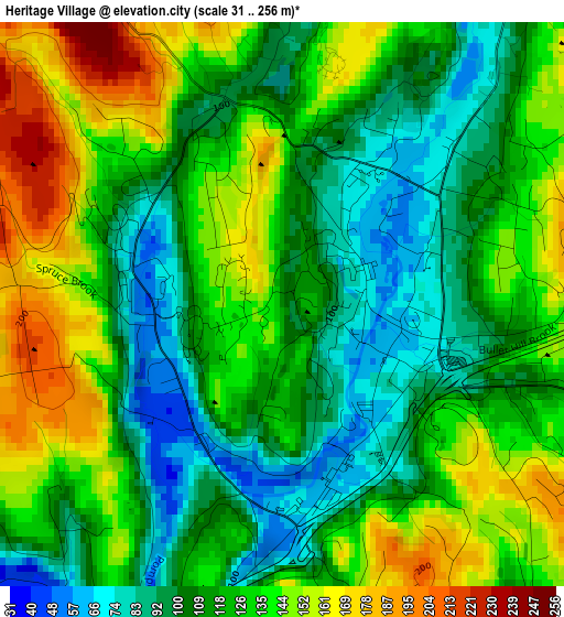
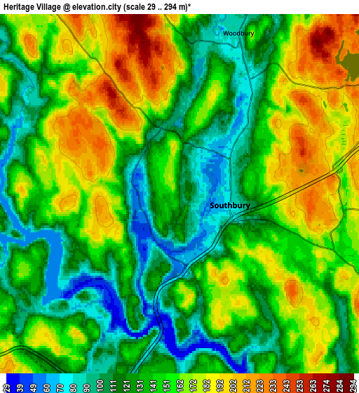
Below is the Elevation map of Heritage Village, which displays elevation range with different colors. Scale of the first map is from 31 to 256 m (102 to 840 ft) with average elevation of 123.1 meters (=404 ft) [note 1]
These maps also provides idea of topography and contour of this city, they are displayed at different zoom levels. More info about maps, scale and edge coordinates you can find below images.
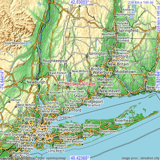
| \ | Map #1 | Map #2 | Topo.Map |
| Scale [m] | 31..256 m | 29..294 m | × |
| Scale [ft] | 102..840 ft | 95..965 ft | × |
| Average | 123.1 m = 404 ft | 146.1 m = 479 ft | × |
| Width | 7.32 km = 4.5 mi | 14.64 km = 9.1 mi | 234.3 km = 145.6 mi |
| Height | 7.32 km = 4.5 mi | 14.64 km = 9.1 mi | 234.3 km = 145.6 mi |
| ↑Max Latitude | 41.518562° | 41.551457° | 42.53053° |
| Latitude at center | 41.48565° | 41.48565° | 41.48565° |
| ↓Min Latitude | 41.452721° | 41.419776° | 40.42365° |
| ← Min Longitude | -73.281835° | -73.325781° | -74.64414° |
| Longitude center | -73.23789° | -73.23789° | -73.23789° |
| →Max Longitude | -73.193945° | -73.149999° | -71.83164° |
Nearby cities:
Cities around Heritage Village sort by population:
• Naugatuck elevation 64 m
15.6 km,  89°
89°
• Southbury 77 m
2.1 km,  102°
102°
• Seymour 30 m
16.7 km,  126°
126°
• Oxford 110 m
11.6 km,  119°
119°
• Woodbury 84 m
7 km,  20°
20°
• Oakville 166 m
17.5 km,  46°
46°
• Middlebury 219 m
10.3 km,  62°
62°
• Watertown 181 m
16.7 km,  36°
36°
• Washington 233 m
17.3 km,  339°
339°
• Bethlehem Village 275 m
17.4 km,  9°
9°
• Newtown 145 m
9.7 km,  214°
214°
• Woodbury Center 138 m
7.1 km, 22°
Multilingual:
 En español:
Heritage Village elevación 104 m.
 En France:
Heritage Village élévation 104 m.
 Auf Deutsch:
Heritage Village höhe über dem Meeresspiegel ist 104 m.

Sources and notes:
- [note 1] Map square and city borders are not equal. Map elevation data is calculated only from area inside that square.
- [src 1] Elevation data from geonames database provided with same terms of usage.
- [src 2] The elevation map of Heritage Village is generated using elevation data from NASA's 3 arcsec (90m) resolution SRTM data.
- [src 3] Base (background) map © OpenStreetMap contributors tiles are generated by Geofabrik and OpenTopoMap.
Copyright & License:
This Heritage Village Elevation Map is licensed under CC BY-SA. You may reuse any part from this page, if you give a proper credit by linking to this URL:
 More info on terms of use page.