Sherwood elevation
Sherwood (Arkansas, Pulaski County), United States elevation is 105 meters and Sherwood elevation in feet is 344 ft above sea level [src 1]. Sherwood is a populated place (feature code) with elevation that is 174 meters (571 ft) smaller than average city elevation in United States.
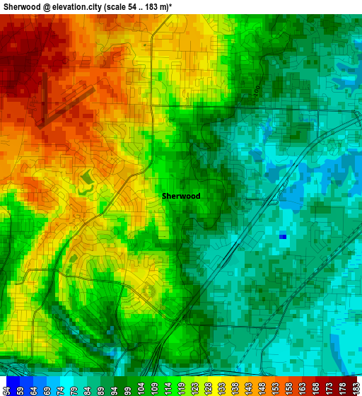
Below is the Elevation map of Sherwood, which displays elevation range with different colors. Scale of the first map is from 54 to 183 m (177 to 600 ft) with average elevation of 111 meters (=364 ft) [note 1]
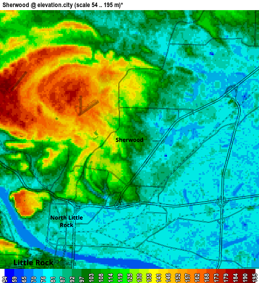
These maps also provides idea of topography and contour of this city, they are displayed at different zoom levels. More info about maps, scale and edge coordinates you can find below images.
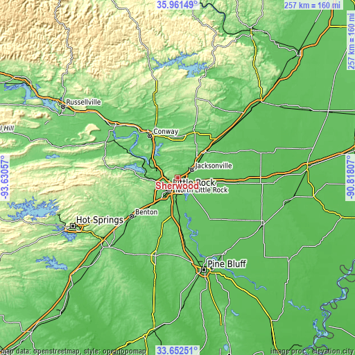
| \ | Map #1 | Map #2 | Topo.Map |
| Scale [m] | 54..183 m | 54..195 m | × |
| Scale [ft] | 177..600 ft | 177..640 ft | × |
| Average | 111 m = 364 ft | 102.3 m = 336 ft | × |
| Width | 8.02 km = 5 mi | 16.05 km = 10 mi | 256.7 km = 159.5 mi |
| Height | 8.02 km = 5 mi | 16.05 km = 10 mi | 256.7 km = 159.5 mi |
| ↑Max Latitude | 34.851161° | 34.887216° | 35.96149° |
| Latitude at center | 34.81509° | 34.81509° | 34.81509° |
| ↓Min Latitude | 34.779003° | 34.7429° | 33.65251° |
| ← Min Longitude | -92.268265° | -92.312211° | -93.63057° |
| Longitude center | -92.22432° | -92.22432° | -92.22432° |
| →Max Longitude | -92.180375° | -92.136429° | -90.81807° |
Nearby cities:
Cities around Sherwood sort by population:
• Little Rock elevation 105 m
9.7 km,  218°
218°
• North Little Rock 83 m
6.4 km, 217°
• Jacksonville 90 m
11.9 km,  61°
61°
• Cabot 95 m
25.9 km,  46°
46°
• Maumelle 107 m
17.4 km,  289°
289°
• Landmark 127 m
24.3 km,  201°
201°
• Gibson 83 m
7.8 km,  352°
352°
• Gravel Ridge 85 m
6.7 km,  27°
27°
• Mayflower 89 m
24.3 km,  310°
310°
• Wrightsville 81 m
23.7 km,  178°
178°
• McAlmont 86 m
4 km,  100°
100°
• Little Rock Air Force Base 115 m
10.3 km, 34°
Multilingual:
 En español:
Sherwood elevación 105 m.
 En France:
Sherwood élévation 105 m.
 Auf Deutsch:
Sherwood höhe über dem Meeresspiegel ist 105 m.

Sources and notes:
- [note 1] Map square and city borders are not equal. Map elevation data is calculated only from area inside that square.
- [src 1] Elevation data from geonames database provided with same terms of usage.
- [src 2] The elevation map of Sherwood is generated using elevation data from NASA's 3 arcsec (90m) resolution SRTM data.
- [src 3] Base (background) map © OpenStreetMap contributors tiles are generated by Geofabrik and OpenTopoMap.
Copyright & License:
This Sherwood Elevation Map is licensed under CC BY-SA. You may reuse any part from this page, if you give a proper credit by linking to this URL:
 More info on terms of use page.