Jacksonville elevation
Jacksonville (Arkansas, Pulaski County), United States elevation is 90 meters and Jacksonville elevation in feet is 295 ft above sea level [src 1]. Jacksonville is a populated place (feature code) with elevation that is 189 meters (620 ft) smaller than average city elevation in United States.
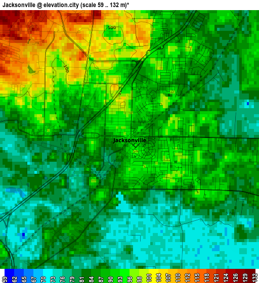
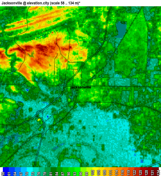
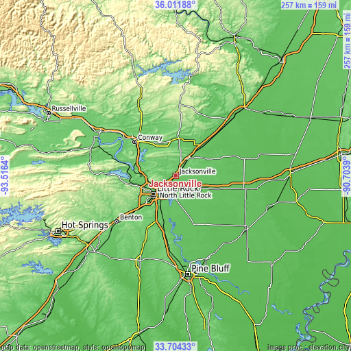
Below is the Elevation map of Jacksonville, which displays elevation range with different colors. Scale of the first map is from 59 to 132 m (194 to 433 ft) with average elevation of 87.2 meters (=286 ft) [note 1]
These maps also provides idea of topography and contour of this city, they are displayed at different zoom levels. More info about maps, scale and edge coordinates you can find below images.
| \ | Map #1 | Map #2 | Topo.Map |
| Scale [m] | 59..132 m | 58..134 m | × |
| Scale [ft] | 194..433 ft | 190..440 ft | × |
| Average | 87.2 m = 286 ft | 86.2 m = 283 ft | × |
| Width | 8.02 km = 5 mi | 16.04 km = 10 mi | 256.6 km = 159.4 mi |
| Height | 8.02 km = 5 mi | 16.04 km = 10 mi | 256.6 km = 159.4 mi |
| ↑Max Latitude | 34.902249° | 34.938282° | 36.01188° |
| Latitude at center | 34.8662° | 34.8662° | 34.8662° |
| ↓Min Latitude | 34.830135° | 34.794055° | 33.70433° |
| ← Min Longitude | -92.154095° | -92.198041° | -93.5164° |
| Longitude center | -92.11015° | -92.11015° | -92.11015° |
| →Max Longitude | -92.066205° | -92.022259° | -90.7039° |
Nearby cities:
Cities around Jacksonville sort by population:
• Little Rock elevation 105 m
21.1 km,  230°
230°
• North Little Rock 83 m
17.9 km, 233°
• Sherwood 105 m
11.9 km,  241°
241°
• Cabot 95 m
14.8 km,  35°
35°
• Ward 76 m
23.3 km, 38°
• Vilonia 96 m
25.8 km,  339°
339°
• Lonoke 76 m
21.3 km,  115°
115°
• Gibson 83 m
11.6 km,  279°
279°
• Austin 80 m
18.7 km, 38°
• Gravel Ridge 85 m
7.4 km,  271°
271°
• McAlmont 86 m
9.2 km, 225°
• Little Rock Air Force Base 115 m
5.3 km,  301°
301°
Multilingual:
 En español:
Jacksonville elevación 90 m.
 En France:
Jacksonville élévation 90 m.
 Auf Deutsch:
Jacksonville höhe über dem Meeresspiegel ist 90 m.
 На русском:
Джексонвилл, Джэксонвилл высота над уровнем моря 90 м
Sources and notes:
- [note 1] Map square and city borders are not equal. Map elevation data is calculated only from area inside that square.
- [src 1] Elevation data from geonames database provided with same terms of usage.
- [src 2] The elevation map of Jacksonville is generated using elevation data from NASA's 3 arcsec (90m) resolution SRTM data.
- [src 3] Base (background) map © OpenStreetMap contributors tiles are generated by Geofabrik and OpenTopoMap.
Copyright & License:
This Jacksonville Elevation Map is licensed under CC BY-SA. You may reuse any part from this page, if you give a proper credit by linking to this URL:
 More info on terms of use page.