Point Pleasant elevation
Point Pleasant (West Virginia, Mason County), United States elevation is 173 meters and Point Pleasant elevation in feet is 568 ft above sea level [src 1]. Point Pleasant is a seat of a second-order administrative division (feature code) with elevation that is 106 meters (348 ft) smaller than average city elevation in United States.
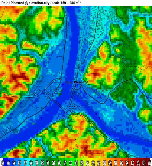
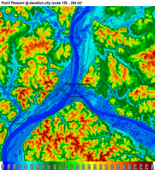
Below is the Elevation map of Point Pleasant, which displays elevation range with different colors. Scale of the first map is from 159 to 284 m (522 to 932 ft) with average elevation of 198.6 meters (=652 ft) [note 1]
These maps also provides idea of topography and contour of this city, they are displayed at different zoom levels. More info about maps, scale and edge coordinates you can find below images.
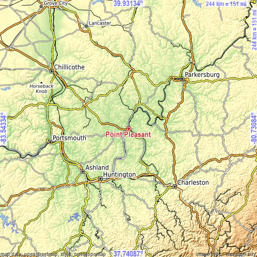
| \ | Map #1 | Map #2 | Topo.Map |
| Scale [m] | 159..284 m | 159..284 m | × |
| Scale [ft] | 522..932 ft | 522..932 ft | × |
| Average | 198.6 m = 652 ft | 206.6 m = 678 ft | × |
| Width | 7.61 km = 4.7 mi | 15.22 km = 9.5 mi | 243.6 km = 151.4 mi |
| Height | 7.61 km = 4.7 mi | 15.22 km = 9.5 mi | 243.6 km = 151.4 mi |
| ↑Max Latitude | 38.878749° | 38.912951° | 39.93134° |
| Latitude at center | 38.84453° | 38.84453° | 38.84453° |
| ↓Min Latitude | 38.810295° | 38.776043° | 37.74087° |
| ← Min Longitude | -82.181035° | -82.224981° | -83.54334° |
| Longitude center | -82.13709° | -82.13709° | -82.13709° |
| →Max Longitude | -82.093145° | -82.049199° | -80.73084° |
Nearby cities:
Cities around Point Pleasant sort by population:
• Ravenswood elevation 187 m
34.5 km,  70°
70°
• Gallipolis 177 m
6.8 km,  235°
235°
• Ripley 185 m
37 km,  94°
94°
• Milton 178 m
45.6 km,  179°
179°
• Middleport 177 m
19.1 km,  23°
23°
• Winfield 184 m
40.6 km,  148°
148°
• Pomeroy 182 m
22.2 km, 23°
• Eleanor 182 m
38.5 km, 152°
• New Haven 182 m
21.2 km,  41°
41°
• Oak Hill 215 m
38.2 km,  278°
278°
• Lesage 173 m
40.1 km,  200°
200°
• Buffalo 173 m
28.6 km, 151°
Multilingual:
 En español:
Point Pleasant elevación 173 m.
 En France:
Point Pleasant élévation 173 m.
 Auf Deutsch:
Point Pleasant höhe über dem Meeresspiegel ist 173 m.

Sources and notes:
- [note 1] Map square and city borders are not equal. Map elevation data is calculated only from area inside that square.
- [src 1] Elevation data from geonames database provided with same terms of usage.
- [src 2] The elevation map of Point Pleasant is generated using elevation data from NASA's 3 arcsec (90m) resolution SRTM data.
- [src 3] Base (background) map © OpenStreetMap contributors tiles are generated by Geofabrik and OpenTopoMap.
Copyright & License:
This Point Pleasant Elevation Map is licensed under CC BY-SA. You may reuse any part from this page, if you give a proper credit by linking to this URL:
 More info on terms of use page.