Pomeroy elevation
Pomeroy (Ohio, Meigs County), United States elevation is 182 meters and Pomeroy elevation in feet is 597 ft above sea level [src 1]. Pomeroy is a seat of a second-order administrative division (feature code) with elevation that is 97 meters (318 ft) smaller than average city elevation in United States.
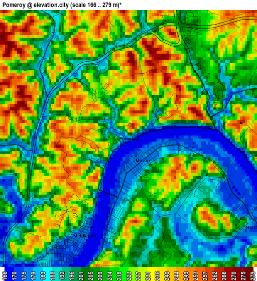
Below is the Elevation map of Pomeroy, which displays elevation range with different colors. Scale of the first map is from 166 to 279 m (545 to 915 ft) with average elevation of 211.9 meters (=695 ft) [note 1]
These maps also provides idea of topography and contour of this city, they are displayed at different zoom levels. More info about maps, scale and edge coordinates you can find below images.
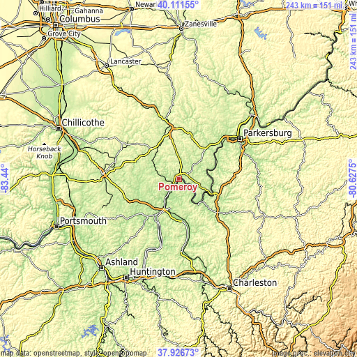
| \ | Map #1 | Topo.Map |
| Scale [m] | 166..279 m | × |
| Scale [ft] | 545..915 ft | × |
| Average | 211.9 m = 695 ft | × |
| Width | 7.59 km = 4.7 mi | 242.9 km = 150.9 mi |
| Height | 7.59 km = 4.7 mi | 242.9 km = 150.9 mi |
| ↑Max Latitude | 39.06171° | 40.11155° |
| Latitude at center | 39.02758° | 39.02758° |
| ↓Min Latitude | 38.993433° | 37.92673° |
| ← Min Longitude | -82.077695° | -83.44° |
| Longitude center | -82.03375° | -82.03375° |
| →Max Longitude | -81.989805° | -80.6275° |
Nearby cities:
Cities around Pomeroy sort by population:
• Athens elevation 224 m
34 km,  350°
350°
• Point Pleasant 173 m
22.2 km,  203°
203°
• Ravenswood 187 m
25.2 km,  110°
110°
• Gallipolis 177 m
28.3 km,  211°
211°
• Ripley 185 m
36.3 km,  129°
129°
• Blennerhassett 237 m
43.7 km,  53°
53°
• The Plains 218 m
38.9 km, 347°
• Middleport 177 m
3.2 km, 204°
• New Haven 182 m
6.9 km, 131°
• Lubeck 232 m
41.7 km,  56°
56°
• Washington 210 m
40.6 km, 50°
• Chauncey 202 m
42 km, 348°
Multilingual:
 En español:
Pomeroy elevación 182 m.
 En France:
Pomeroy élévation 182 m.


Sources and notes:
- [note 1] Map square and city borders are not equal. Map elevation data is calculated only from area inside that square.
- [src 1] Elevation data from geonames database provided with same terms of usage.
- [src 2] The elevation map of Pomeroy is generated using elevation data from NASA's 3 arcsec (90m) resolution SRTM data.
- [src 3] Base (background) map © OpenStreetMap contributors tiles are generated by Geofabrik and OpenTopoMap.
Copyright & License:
This Pomeroy Elevation Map is licensed under CC BY-SA. You may reuse any part from this page, if you give a proper credit by linking to this URL:
 More info on terms of use page.