Charles Town elevation
Charles Town (West Virginia, Jefferson County), United States elevation is 157 meters and Charles Town elevation in feet is 515 ft above sea level [src 1]. Charles Town is a seat of a second-order administrative division (feature code) with elevation that is 122 meters (400 ft) smaller than average city elevation in United States.
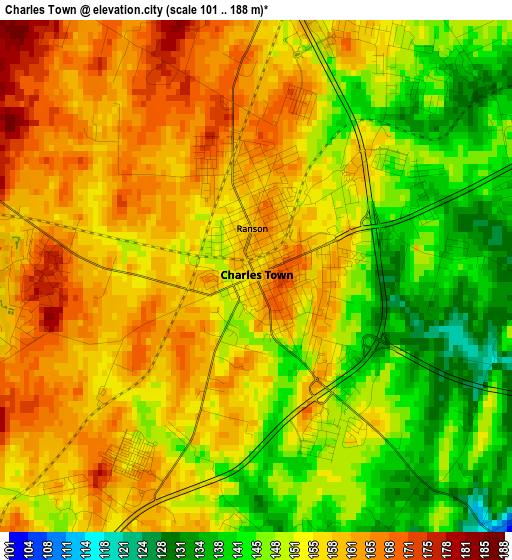
Below is the Elevation map of Charles Town, which displays elevation range with different colors. Scale of the first map is from 101 to 188 m (331 to 617 ft) with average elevation of 153.3 meters (=503 ft) [note 1]
These maps also provides idea of topography and contour of this city, they are displayed at different zoom levels. More info about maps, scale and edge coordinates you can find below images.
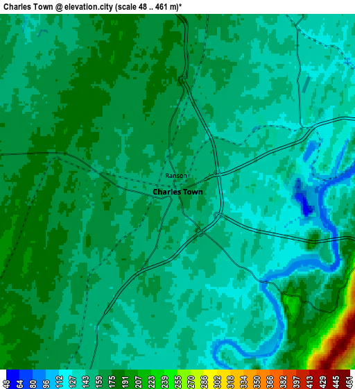
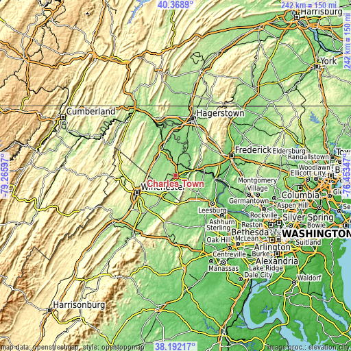
| \ | Map #1 | Map #2 | Topo.Map |
| Scale [m] | 101..188 m | 48..461 m | × |
| Scale [ft] | 331..617 ft | 157..1512 ft | × |
| Average | 153.3 m = 503 ft | 158 m = 518 ft | × |
| Width | 7.56 km = 4.7 mi | 15.13 km = 9.4 mi | 242 km = 150.4 mi |
| Height | 7.56 km = 4.7 mi | 15.13 km = 9.4 mi | 242 km = 150.4 mi |
| ↑Max Latitude | 39.322994° | 39.356981° | 40.3689° |
| Latitude at center | 39.28899° | 39.28899° | 39.28899° |
| ↓Min Latitude | 39.25497° | 39.220933° | 38.19217° |
| ← Min Longitude | -77.903665° | -77.947611° | -79.26597° |
| Longitude center | -77.85972° | -77.85972° | -77.85972° |
| →Max Longitude | -77.815775° | -77.771829° | -76.45347° |
Nearby cities:
Cities around Charles Town sort by population:
• Martinsburg elevation 139 m
20.6 km,  334°
334°
• Purcellville 172 m
21 km,  143°
143°
• Brunswick 86 m
20.2 km,  81°
81°
• Ranson 159 m
0.7 km,  353°
353°
• Berryville 177 m
18.6 km,  214°
214°
• Shannondale 175 m
9.2 km,  150°
150°
• Inwood 171 m
17.3 km,  296°
296°
• Shepherdstown 123 m
16.4 km,  16°
16°
• Lovettsville 154 m
19.3 km,  95°
95°
• Point of Rocks 79 m
27.6 km,  93°
93°
• Keedysville 122 m
25.9 km,  32°
32°
• Bolivar 151 m
10 km,  67°
67°
Multilingual:
 En español:
Charles Town elevación 157 m.
 En France:
Charles Town élévation 157 m.
 Auf Deutsch:
Charles Town höhe über dem Meeresspiegel ist 157 m.

Sources and notes:
- [note 1] Map square and city borders are not equal. Map elevation data is calculated only from area inside that square.
- [src 1] Elevation data from geonames database provided with same terms of usage.
- [src 2] The elevation map of Charles Town is generated using elevation data from NASA's 3 arcsec (90m) resolution SRTM data.
- [src 3] Base (background) map © OpenStreetMap contributors tiles are generated by Geofabrik and OpenTopoMap.
Copyright & License:
This Charles Town Elevation Map is licensed under CC BY-SA. You may reuse any part from this page, if you give a proper credit by linking to this URL:
 More info on terms of use page.