Berkeley Springs elevation
Berkeley Springs (West Virginia, Morgan County), United States elevation is 217 meters and Berkeley Springs elevation in feet is 712 ft above sea level [src 1]. Berkeley Springs is a seat of a second-order administrative division (feature code) with elevation that is 62 meters (203 ft) smaller than average city elevation in United States.
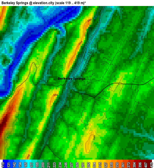
Below is the Elevation map of Berkeley Springs, which displays elevation range with different colors. Scale of the first map is from 119 to 419 m (390 to 1375 ft) with average elevation of 232.5 meters (=763 ft) [note 1]
These maps also provides idea of topography and contour of this city, they are displayed at different zoom levels. More info about maps, scale and edge coordinates you can find below images.
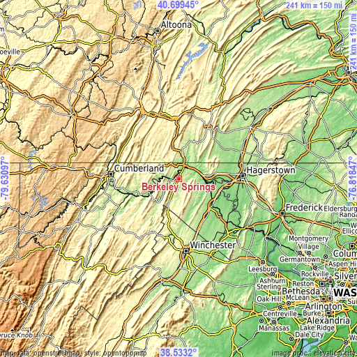
| \ | Map #1 | Topo.Map |
| Scale [m] | 119..419 m | × |
| Scale [ft] | 390..1375 ft | × |
| Average | 232.5 m = 763 ft | × |
| Width | 7.53 km = 4.7 mi | 240.9 km = 149.7 mi |
| Height | 7.53 km = 4.7 mi | 240.9 km = 149.7 mi |
| ↑Max Latitude | 39.65864° | 40.69945° |
| Latitude at center | 39.6248° | 39.6248° |
| ↓Min Latitude | 39.590943° | 38.5332° |
| ← Min Longitude | -78.268665° | -79.63097° |
| Longitude center | -78.22472° | -78.22472° |
| →Max Longitude | -78.180775° | -76.81847° |
Nearby cities:
Cities around Berkeley Springs sort by population:
• Hagerstown elevation 168 m
43.3 km,  87°
87°
• Martinsburg 139 m
29.2 km,  129°
129°
• Halfway 184 m
39.9 km, 90°
• Maugansville 188 m
41.8 km,  79°
79°
• Inwood 171 m
33.6 km,  151°
151°
• Saint James 137 m
40.6 km,  99°
99°
• Wilson-Conococheague 132 m
33.8 km, 84°
• Williamsport 125 m
34.7 km, 94°
• Shepherdstown 123 m
42.1 km,  120°
120°
• Mercersburg 177 m
35.6 km,  50°
50°
• Hancock 139 m
9.1 km,  25°
25°
• McConnellsburg 270 m
39.3 km, 29°
Multilingual:
 En español:
Berkeley Springs elevación 217 m.
 En France:
Berkeley Springs élévation 217 m.
 Auf Deutsch:
Berkeley Springs höhe über dem Meeresspiegel ist 217 m.

Sources and notes:
- [note 1] Map square and city borders are not equal. Map elevation data is calculated only from area inside that square.
- [src 1] Elevation data from geonames database provided with same terms of usage.
- [src 2] The elevation map of Berkeley Springs is generated using elevation data from NASA's 3 arcsec (90m) resolution SRTM data.
- [src 3] Base (background) map © OpenStreetMap contributors tiles are generated by Geofabrik and OpenTopoMap.
Copyright & License:
This Berkeley Springs Elevation Map is licensed under CC BY-SA. You may reuse any part from this page, if you give a proper credit by linking to this URL:
 More info on terms of use page.