Waverly elevation
Waverly (Virginia, Sussex County), United States elevation is 38 meters and Waverly elevation in feet is 125 ft above sea level [src 1]. Waverly is a populated place (feature code) with elevation that is 241 meters (791 ft) smaller than average city elevation in United States.
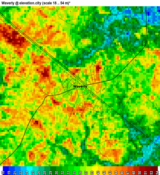
Below is the Elevation map of Waverly, which displays elevation range with different colors. Scale of the first map is from 18 to 54 m (59 to 177 ft) with average elevation of 36.6 meters (=120 ft) [note 1]
These maps also provides idea of topography and contour of this city, they are displayed at different zoom levels. More info about maps, scale and edge coordinates you can find below images.
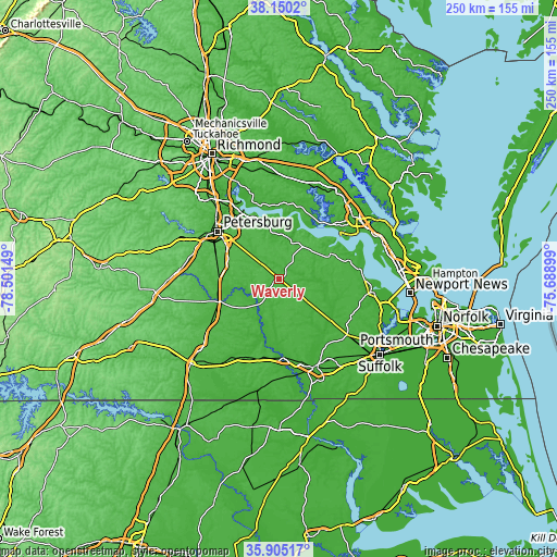
| \ | Map #1 | Topo.Map |
| Scale [m] | 18..54 m | × |
| Scale [ft] | 59..177 ft | × |
| Average | 36.6 m = 120 ft | × |
| Width | 7.8 km = 4.8 mi | 249.6 km = 155.1 mi |
| Height | 7.8 km = 4.8 mi | 249.6 km = 155.1 mi |
| ↑Max Latitude | 37.071052° | 38.1502° |
| Latitude at center | 37.03598° | 37.03598° |
| ↓Min Latitude | 37.000892° | 35.90517° |
| ← Min Longitude | -77.139185° | -78.50149° |
| Longitude center | -77.09524° | -77.09524° |
| →Max Longitude | -77.051295° | -75.68899° |
Nearby cities:
Cities around Waverly sort by population:
• Petersburg elevation 22 m
34.6 km,  308°
308°
• Hopewell 16 m
34.3 km,  330°
330°
• Colonial Heights 19 m
37.8 km, 313°
• Ettrick 33 m
37.4 km, 307°
• Fort Lee 29 m
31.6 km,  317°
317°
• Prince George 41 m
26.7 km, 320°
• Courtland 10 m
35.6 km,  176°
176°
• Rushmere 22 m
37.3 km,  84°
84°
• Sussex 39 m
21.2 km,  230°
230°
• Surry 37 m
25.7 km,  63°
63°
• Charles City 13 m
34.2 km,  3°
3°
• Isle of Wight 21 m
37.3 km,  112°
112°
Multilingual:
 En español:
Waverly elevación 38 m.
 En France:
Waverly élévation 38 m.


Sources and notes:
- [note 1] Map square and city borders are not equal. Map elevation data is calculated only from area inside that square.
- [src 1] Elevation data from geonames database provided with same terms of usage.
- [src 2] The elevation map of Waverly is generated using elevation data from NASA's 3 arcsec (90m) resolution SRTM data.
- [src 3] Base (background) map © OpenStreetMap contributors tiles are generated by Geofabrik and OpenTopoMap.
Copyright & License:
This Waverly Elevation Map is licensed under CC BY-SA. You may reuse any part from this page, if you give a proper credit by linking to this URL:
 More info on terms of use page.