Staunton elevation
Staunton (Virginia, City of Staunton), United States elevation is 434 meters and Staunton elevation in feet is 1424 ft above sea level [src 1]. Staunton is a seat of a second-order administrative division (feature code) with elevation that is 155 meters (509 ft) bigger than average city elevation in United States.
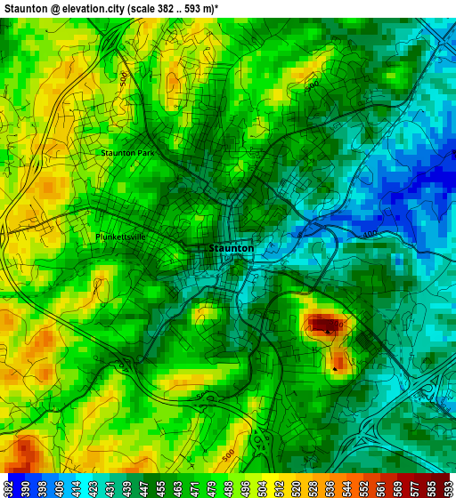
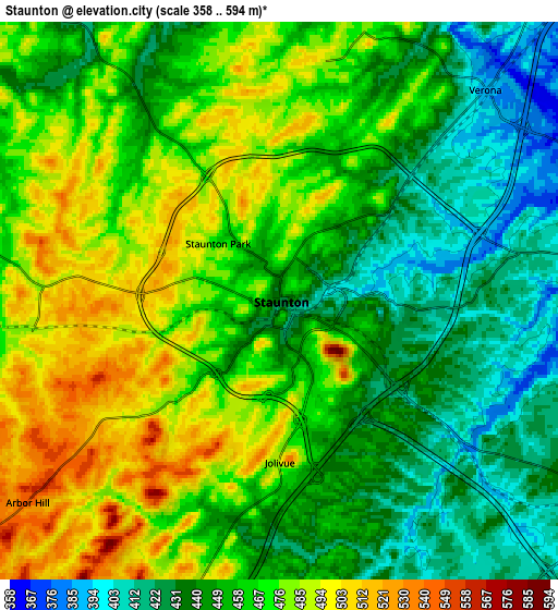
Below is the Elevation map of Staunton, which displays elevation range with different colors. Scale of the first map is from 382 to 593 m (1253 to 1946 ft) with average elevation of 466.2 meters (=1530 ft) [note 1]
These maps also provides idea of topography and contour of this city, they are displayed at different zoom levels. More info about maps, scale and edge coordinates you can find below images.
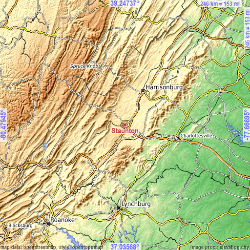
| \ | Map #1 | Map #2 | Topo.Map |
| Scale [m] | 382..593 m | 358..594 m | × |
| Scale [ft] | 1253..1946 ft | 1175..1949 ft | × |
| Average | 466.2 m = 1530 ft | 459.7 m = 1508 ft | × |
| Width | 7.69 km = 4.8 mi | 15.37 km = 9.6 mi | 245.9 km = 152.8 mi |
| Height | 7.69 km = 4.8 mi | 15.37 km = 9.6 mi | 245.9 km = 152.8 mi |
| ↑Max Latitude | 38.18446° | 38.218994° | 39.24737° |
| Latitude at center | 38.14991° | 38.14991° | 38.14991° |
| ↓Min Latitude | 38.115343° | 38.08076° | 37.03568° |
| ← Min Longitude | -79.117145° | -79.161091° | -80.47945° |
| Longitude center | -79.0732° | -79.0732° | -79.0732° |
| →Max Longitude | -79.029255° | -78.985309° | -77.66695° |
Nearby cities:
Cities around Staunton sort by population:
• Waynesboro elevation 393 m
18.4 km,  119°
119°
• Stuarts Draft 433 m
13.8 km,  165°
165°
• Fishersville 404 m
10.7 km, 121°
• Bridgewater 360 m
27.2 km,  18°
18°
• Verona 390 m
8.1 km,  44°
44°
• Grottoes 339 m
25.2 km,  58°
58°
• Weyers Cave 355 m
20.8 km, 42°
• Crimora 380 m
19.5 km,  88°
88°
• Dayton 367 m
31.7 km, 21°
• Lyndhurst 425 m
17.5 km,  140°
140°
• Dooms 384 m
19.4 km,  103°
103°
• Jolivue 491 m
4.5 km,  179°
179°
Multilingual:
 En español:
Staunton elevación 434 m.
 En France:
Staunton élévation 434 m.
 Auf Deutsch:
Staunton höhe über dem Meeresspiegel ist 434 m.

Sources and notes:
- [note 1] Map square and city borders are not equal. Map elevation data is calculated only from area inside that square.
- [src 1] Elevation data from geonames database provided with same terms of usage.
- [src 2] The elevation map of Staunton is generated using elevation data from NASA's 3 arcsec (90m) resolution SRTM data.
- [src 3] Base (background) map © OpenStreetMap contributors tiles are generated by Geofabrik and OpenTopoMap.
Copyright & License:
This Staunton Elevation Map is licensed under CC BY-SA. You may reuse any part from this page, if you give a proper credit by linking to this URL:
 More info on terms of use page.