Stanleytown elevation
Stanleytown (Virginia, Henry County), United States elevation is 233 meters and Stanleytown elevation in feet is 764 ft above sea level [src 1]. Stanleytown is a populated place (feature code) with elevation that is 46 meters (151 ft) smaller than average city elevation in United States.
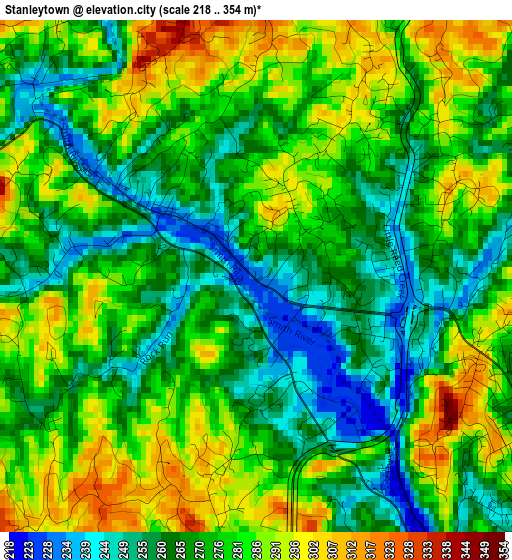
Below is the Elevation map of Stanleytown, which displays elevation range with different colors. Scale of the first map is from 218 to 354 m (715 to 1161 ft) with average elevation of 274.2 meters (=900 ft) [note 1]
These maps also provides idea of topography and contour of this city, they are displayed at different zoom levels. More info about maps, scale and edge coordinates you can find below images.
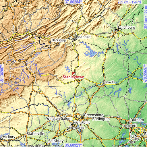
| \ | Map #1 | Topo.Map |
| Scale [m] | 218..354 m | × |
| Scale [ft] | 715..1161 ft | × |
| Average | 274.2 m = 900 ft | × |
| Width | 7.83 km = 4.9 mi | 250.6 km = 155.7 mi |
| Height | 7.83 km = 4.9 mi | 250.6 km = 155.7 mi |
| ↑Max Latitude | 36.779506° | 37.86284° |
| Latitude at center | 36.7443° | 36.7443° |
| ↓Min Latitude | 36.709078° | 35.60921° |
| ← Min Longitude | -80.006765° | -81.36907° |
| Longitude center | -79.96282° | -79.96282° |
| →Max Longitude | -79.918875° | -78.55657° |
Nearby cities:
Cities around Stanleytown sort by population:
• Martinsville elevation 309 m
10 km,  126°
126°
• Collinsville 246 m
5.3 km, 127°
• Rocky Mount 347 m
28.9 km,  12°
12°
• Pannill Fork 330 m
6 km,  228°
228°
• Horse Pasture 335 m
12.9 km,  175°
175°
• Ferrum 396 m
20.4 km,  347°
347°
• Patrick Springs 384 m
23.6 km,  241°
241°
• Chatmoss 203 m
16.6 km, 125°
• Stuart 408 m
29.3 km,  246°
246°
• Henry Fork 375 m
26 km,  18°
18°
• Bassett 234 m
3 km,  304°
304°
• Stoneville 249 m
31.3 km,  170°
170°
Multilingual:
 En español:
Stanleytown elevación 233 m.
 En France:
Stanleytown élévation 233 m.
 Auf Deutsch:
Stanleytown höhe über dem Meeresspiegel ist 233 m.

Sources and notes:
- [note 1] Map square and city borders are not equal. Map elevation data is calculated only from area inside that square.
- [src 1] Elevation data from geonames database provided with same terms of usage.
- [src 2] The elevation map of Stanleytown is generated using elevation data from NASA's 3 arcsec (90m) resolution SRTM data.
- [src 3] Base (background) map © OpenStreetMap contributors tiles are generated by Geofabrik and OpenTopoMap.
Copyright & License:
This Stanleytown Elevation Map is licensed under CC BY-SA. You may reuse any part from this page, if you give a proper credit by linking to this URL:
 More info on terms of use page.