Shawnee Land elevation
Shawnee Land (Virginia, Frederick County), United States elevation is 345 meters and Shawnee Land elevation in feet is 1132 ft above sea level [src 1]. Shawnee Land is a populated place (feature code) with elevation that is 66 meters (217 ft) bigger than average city elevation in United States.
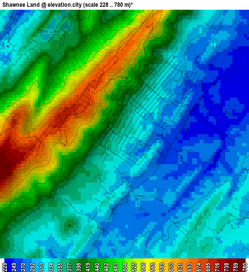
Below is the Elevation map of Shawnee Land, which displays elevation range with different colors. Scale of the first map is from 228 to 780 m (748 to 2559 ft) with average elevation of 383.5 meters (=1258 ft) [note 1]
These maps also provides idea of topography and contour of this city, they are displayed at different zoom levels. More info about maps, scale and edge coordinates you can find below images.
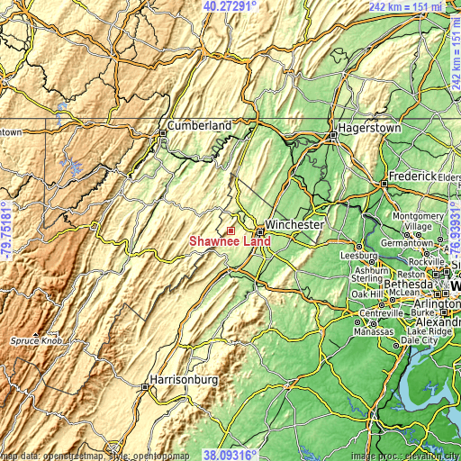
| \ | Map #1 | Topo.Map |
| Scale [m] | 228..780 m | × |
| Scale [ft] | 748..2559 ft | × |
| Average | 383.5 m = 1258 ft | × |
| Width | 7.57 km = 4.7 mi | 242.4 km = 150.6 mi |
| Height | 7.57 km = 4.7 mi | 242.4 km = 150.6 mi |
| ↑Max Latitude | 39.225541° | 40.27291° |
| Latitude at center | 39.19149° | 39.19149° |
| ↓Min Latitude | 39.157422° | 38.09316° |
| ← Min Longitude | -78.389505° | -79.75181° |
| Longitude center | -78.34556° | -78.34556° |
| →Max Longitude | -78.301615° | -76.93931° |
Nearby cities:
Cities around Shawnee Land sort by population:
• Winchester elevation 217 m
15.7 km,  92°
92°
• Front Royal 172 m
33.1 km,  156°
156°
• Strasburg 174 m
22.6 km,  182°
182°
• Charles Town 157 m
43.2 km,  75°
75°
• Woodstock 241 m
37.1 km,  201°
201°
• Berryville 177 m
31.6 km,  98°
98°
• Shenandoah Farms 175 m
33 km,  135°
135°
• Inwood 171 m
32.2 km,  54°
54°
• Stephens City 230 m
16.3 km, 137°
• Romney 250 m
39.1 km,  295°
295°
• Apple Mountain Lake 298 m
36.4 km, 144°
• Middletown 219 m
19.1 km, 162°
Multilingual:
 En español:
Shawnee Land elevación 345 m.
 En France:
Shawnee Land élévation 345 m.
 Auf Deutsch:
Shawnee Land höhe über dem Meeresspiegel ist 345 m.

Sources and notes:
- [note 1] Map square and city borders are not equal. Map elevation data is calculated only from area inside that square.
- [src 1] Elevation data from geonames database provided with same terms of usage.
- [src 2] The elevation map of Shawnee Land is generated using elevation data from NASA's 3 arcsec (90m) resolution SRTM data.
- [src 3] Base (background) map © OpenStreetMap contributors tiles are generated by Geofabrik and OpenTopoMap.
Copyright & License:
This Shawnee Land Elevation Map is licensed under CC BY-SA. You may reuse any part from this page, if you give a proper credit by linking to this URL:
 More info on terms of use page.