McLean elevation
McLean (Virginia, Fairfax County), United States elevation is 91 meters and McLean elevation in feet is 299 ft above sea level [src 1]. McLean is a populated place (feature code) with elevation that is 188 meters (617 ft) smaller than average city elevation in United States.
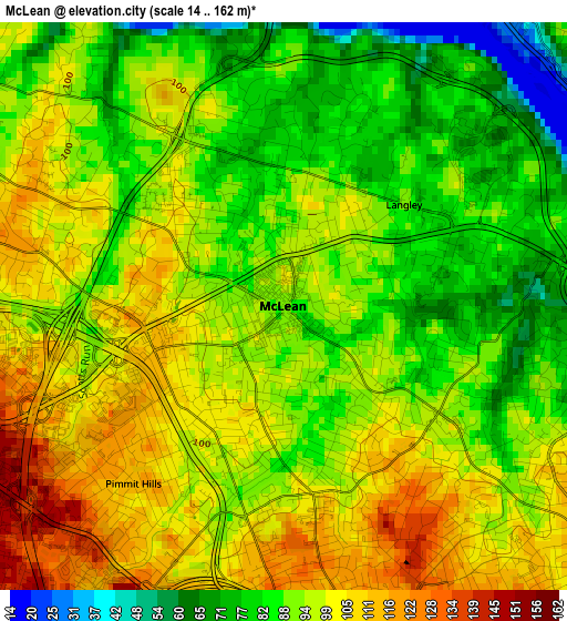
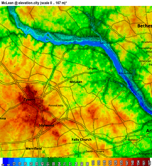
Below is the Elevation map of McLean, which displays elevation range with different colors. Scale of the first map is from 14 to 162 m (46 to 531 ft) with average elevation of 93.6 meters (=307 ft) [note 1]
These maps also provides idea of topography and contour of this city, they are displayed at different zoom levels. More info about maps, scale and edge coordinates you can find below images.
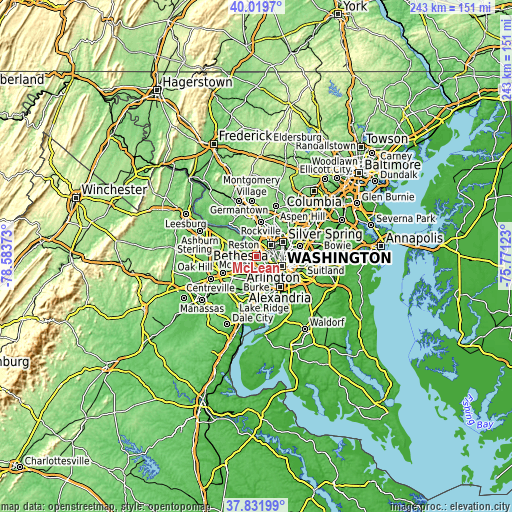
| \ | Map #1 | Map #2 | Topo.Map |
| Scale [m] | 14..162 m | 0..167 m | × |
| Scale [ft] | 46..531 ft | 0..548 ft | × |
| Average | 93.6 m = 307 ft | 93.5 m = 307 ft | × |
| Width | 7.6 km = 4.7 mi | 15.2 km = 9.4 mi | 243.3 km = 151.2 mi |
| Height | 7.6 km = 4.7 mi | 15.2 km = 9.4 mi | 243.2 km = 151.1 mi |
| ↑Max Latitude | 38.968455° | 39.002614° | 40.0197° |
| Latitude at center | 38.93428° | 38.93428° | 38.93428° |
| ↓Min Latitude | 38.900088° | 38.86588° | 37.83199° |
| ← Min Longitude | -77.221425° | -77.265371° | -78.58373° |
| Longitude center | -77.17748° | -77.17748° | -77.17748° |
| →Max Longitude | -77.133535° | -77.089589° | -75.77123° |
Nearby cities:
Cities around McLean sort by population:
• West Falls Church elevation 104 m
4.9 km,  187°
187°
• Jefferson 106 m
7.8 km, 186°
• Tysons Corner 144 m
4.9 km,  249°
249°
• Idylwood 143 m
5.3 km,  214°
214°
• Merrifield 109 m
7.9 km, 212°
• Falls Church 104 m
5.8 km,  174°
174°
• Seven Corners 119 m
7.2 km,  164°
164°
• Dunn Loring 138 m
5.9 km,  220°
220°
• Pimmit Hills 113 m
3.1 km, 220°
• Brookmont 42 m
5 km,  80°
80°
• Cabin John 54 m
4.9 km,  20°
20°
• Somerset 95 m
7.9 km,  63°
63°
Multilingual:
 En español:
McLean elevación 91 m.
 En France:
McLean élévation 91 m.


Sources and notes:
- [note 1] Map square and city borders are not equal. Map elevation data is calculated only from area inside that square.
- [src 1] Elevation data from geonames database provided with same terms of usage.
- [src 2] The elevation map of McLean is generated using elevation data from NASA's 3 arcsec (90m) resolution SRTM data.
- [src 3] Base (background) map © OpenStreetMap contributors tiles are generated by Geofabrik and OpenTopoMap.
Copyright & License:
This McLean Elevation Map is licensed under CC BY-SA. You may reuse any part from this page, if you give a proper credit by linking to this URL:
 More info on terms of use page.