Lovingston elevation
Lovingston (Virginia, Nelson County), United States elevation is 226 meters and Lovingston elevation in feet is 741 ft above sea level [src 1]. Lovingston is a seat of a second-order administrative division (feature code) with elevation that is 53 meters (174 ft) smaller than average city elevation in United States.
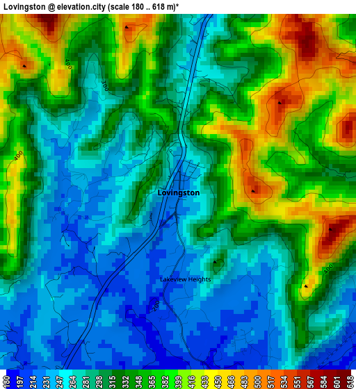
Below is the Elevation map of Lovingston, which displays elevation range with different colors. Scale of the first map is from 180 to 618 m (591 to 2028 ft) with average elevation of 317.3 meters (=1041 ft) [note 1]
These maps also provides idea of topography and contour of this city, they are displayed at different zoom levels. More info about maps, scale and edge coordinates you can find below images.
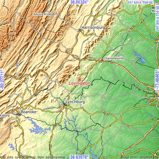
| \ | Map #1 | Topo.Map |
| Scale [m] | 180..618 m | × |
| Scale [ft] | 591..2028 ft | × |
| Average | 317.3 m = 1041 ft | × |
| Width | 7.73 km = 4.8 mi | 247.2 km = 153.6 mi |
| Height | 7.73 km = 4.8 mi | 247.2 km = 153.6 mi |
| ↑Max Latitude | 37.794594° | 38.86324° |
| Latitude at center | 37.75986° | 37.75986° |
| ↓Min Latitude | 37.725109° | 36.63978° |
| ← Min Longitude | -78.914805° | -80.27711° |
| Longitude center | -78.87086° | -78.87086° |
| →Max Longitude | -78.826915° | -77.46461° |
Nearby cities:
Cities around Lovingston sort by population:
• Waynesboro elevation 393 m
34.4 km,  357°
357°
• Madison Heights 230 m
42.8 km,  211°
211°
• Stuarts Draft 433 m
33.3 km,  334°
334°
• Fishersville 404 m
38.7 km,  347°
347°
• Buena Vista 253 m
42.6 km,  266°
266°
• Crozet 217 m
37.5 km,  23°
23°
• Amherst 229 m
25.1 km,  219°
219°
• Lyndhurst 425 m
30.7 km, 347°
• Dooms 384 m
38.8 km,  1°
1°
• Jolivue 491 m
42.8 km,  335°
335°
• Nellysford 208 m
14.5 km, 359°
• Buckingham 137 m
36.3 km,  130°
130°
Multilingual:
 En español:
Lovingston elevación 226 m.
 En France:
Lovingston élévation 226 m.
 Auf Deutsch:
Lovingston höhe über dem Meeresspiegel ist 226 m.

Sources and notes:
- [note 1] Map square and city borders are not equal. Map elevation data is calculated only from area inside that square.
- [src 1] Elevation data from geonames database provided with same terms of usage.
- [src 2] The elevation map of Lovingston is generated using elevation data from NASA's 3 arcsec (90m) resolution SRTM data.
- [src 3] Base (background) map © OpenStreetMap contributors tiles are generated by Geofabrik and OpenTopoMap.
Copyright & License:
This Lovingston Elevation Map is licensed under CC BY-SA. You may reuse any part from this page, if you give a proper credit by linking to this URL:
 More info on terms of use page.