Lexington elevation
Lexington (Virginia, City of Lexington), United States elevation is 322 meters and Lexington elevation in feet is 1056 ft above sea level [src 1]. Lexington is a seat of a second-order administrative division (feature code) with elevation that is 43 meters (141 ft) bigger than average city elevation in United States.
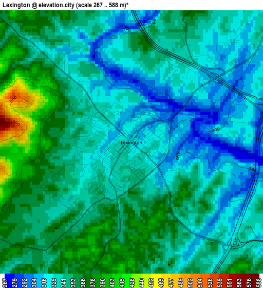
Below is the Elevation map of Lexington, which displays elevation range with different colors. Scale of the first map is from 267 to 588 m (876 to 1929 ft) with average elevation of 344.3 meters (=1130 ft) [note 1]
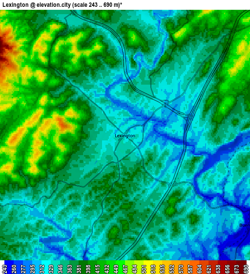
These maps also provides idea of topography and contour of this city, they are displayed at different zoom levels. More info about maps, scale and edge coordinates you can find below images.
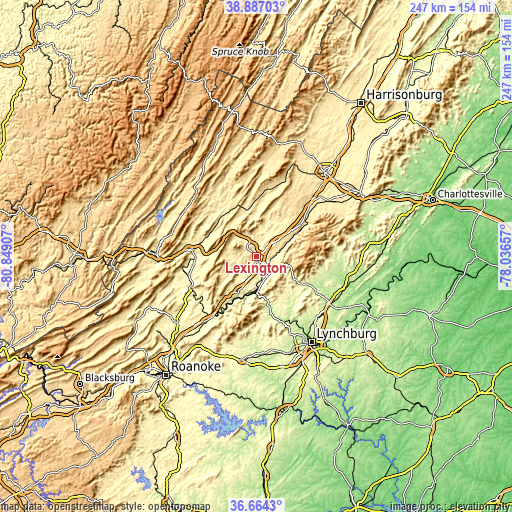
| \ | Map #1 | Map #2 | Topo.Map |
| Scale [m] | 267..588 m | 243..690 m | × |
| Scale [ft] | 876..1929 ft | 797..2264 ft | × |
| Average | 344.3 m = 1130 ft | 368.6 m = 1209 ft | × |
| Width | 7.72 km = 4.8 mi | 15.45 km = 9.6 mi | 247.1 km = 153.5 mi |
| Height | 7.72 km = 4.8 mi | 15.45 km = 9.6 mi | 247.1 km = 153.5 mi |
| ↑Max Latitude | 37.818743° | 37.85345° | 38.88703° |
| Latitude at center | 37.78402° | 37.78402° | 37.78402° |
| ↓Min Latitude | 37.749281° | 37.714525° | 36.6643° |
| ← Min Longitude | -79.486765° | -79.530711° | -80.84907° |
| Longitude center | -79.44282° | -79.44282° | -79.44282° |
| →Max Longitude | -79.398875° | -79.354929° | -78.03657° |
Nearby cities:
Cities around Lexington sort by population:
• West Lynchburg elevation 225 m
48.3 km,  151°
151°
• Madison Heights 230 m
48.3 km,  144°
144°
• Stuarts Draft 433 m
45.1 km,  52°
52°
• Buena Vista 253 m
9.6 km,  125°
125°
• Covington 379 m
48.4 km,  271°
271°
• Clifton Forge 327 m
33.7 km,  276°
276°
• Amherst 229 m
40.9 km,  122°
122°
• Fairlawn 425 m
47.4 km, 268°
• East Lexington 284 m
1.8 km,  57°
57°
• Buchanan 258 m
35.3 km,  216°
216°
• Glasgow 224 m
16.7 km,  182°
182°
• Warm Springs 699 m
42.2 km,  313°
313°
Multilingual:
 En español:
Lexington elevación 322 m.
 En France:
Lexington élévation 322 m.
 Auf Deutsch:
Lexington höhe über dem Meeresspiegel ist 322 m.

Sources and notes:
- [note 1] Map square and city borders are not equal. Map elevation data is calculated only from area inside that square.
- [src 1] Elevation data from geonames database provided with same terms of usage.
- [src 2] The elevation map of Lexington is generated using elevation data from NASA's 3 arcsec (90m) resolution SRTM data.
- [src 3] Base (background) map © OpenStreetMap contributors tiles are generated by Geofabrik and OpenTopoMap.
Copyright & License:
This Lexington Elevation Map is licensed under CC BY-SA. You may reuse any part from this page, if you give a proper credit by linking to this URL:
 More info on terms of use page.