Lawrenceville elevation
Lawrenceville (Virginia, Brunswick County), United States elevation is 76 meters and Lawrenceville elevation in feet is 249 ft above sea level [src 1]. Lawrenceville is a seat of a second-order administrative division (feature code) with elevation that is 203 meters (666 ft) smaller than average city elevation in United States.
Below is the Elevation map of Lawrenceville, which displays elevation range with different colors. Scale of the first map is from 46 to 111 m (151 to 364 ft) with average elevation of 76.4 meters (=251 ft) [note 1]
These maps also provides idea of topography and contour of this city, they are displayed at different zoom levels. More info about maps, scale and edge coordinates you can find below images.
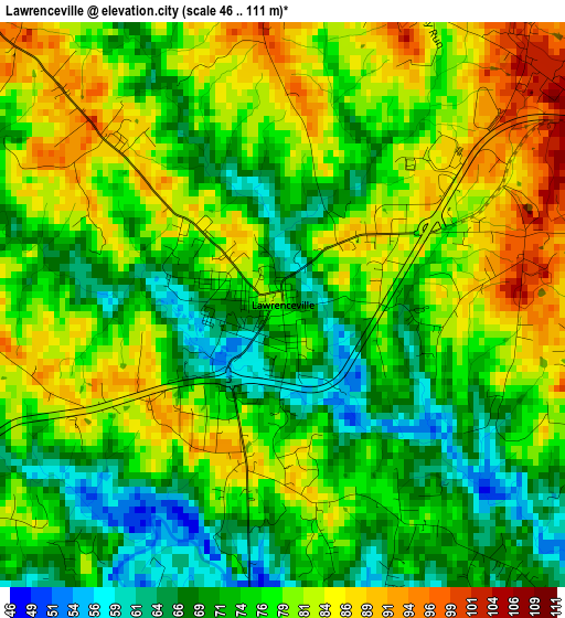
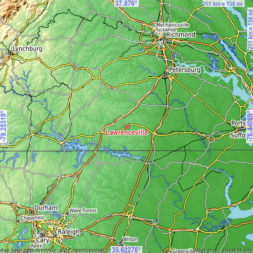
| \ | Map #1 | Topo.Map |
| Scale [m] | 46..111 m | × |
| Scale [ft] | 151..364 ft | × |
| Average | 76.4 m = 251 ft | × |
| Width | 7.83 km = 4.9 mi | 250.5 km = 155.7 mi |
| Height | 7.83 km = 4.9 mi | 250.5 km = 155.7 mi |
| ↑Max Latitude | 36.79285° | 37.876° |
| Latitude at center | 36.75765° | 36.75765° |
| ↓Min Latitude | 36.722434° | 35.62276° |
| ← Min Longitude | -77.890885° | -79.25319° |
| Longitude center | -77.84694° | -77.84694° |
| →Max Longitude | -77.802995° | -76.44069° |
Nearby cities:
Cities around Lawrenceville sort by population:
• Roanoke Rapids elevation 51 m
37.1 km,  152°
152°
• Emporia 40 m
28.3 km,  106°
106°
• South Hill 138 m
25.4 km,  262°
262°
• Blackstone 133 m
38.3 km,  339°
339°
• South Rosemary 72 m
36.6 km,  158°
158°
• Victoria 172 m
42.9 km,  307°
307°
• Weldon 24 m
43.1 km, 148°
• Bracey 111 m
31.7 km,  236°
236°
• Kenbridge 148 m
33.6 km, 312°
• Gaston 58 m
33.8 km, 147°
• Lunenburg 153 m
43.6 km,  301°
301°
• Dinwiddie 82 m
42.5 km,  33°
33°
Multilingual:
 En español:
Lawrenceville elevación 76 m.
 En France:
Lawrenceville élévation 76 m.
 Auf Deutsch:
Lawrenceville höhe über dem Meeresspiegel ist 76 m.

Sources and notes:
- [note 1] Map square and city borders are not equal. Map elevation data is calculated only from area inside that square.
- [src 1] Elevation data from geonames database provided with same terms of usage.
- [src 2] The elevation map of Lawrenceville is generated using elevation data from NASA's 3 arcsec (90m) resolution SRTM data.
- [src 3] Base (background) map © OpenStreetMap contributors tiles are generated by Geofabrik and OpenTopoMap.
Copyright & License:
This Lawrenceville Elevation Map is licensed under CC BY-SA. You may reuse any part from this page, if you give a proper credit by linking to this URL:
 More info on terms of use page.