Grundy elevation
Grundy (Virginia, Buchanan County), United States elevation is 328 meters and Grundy elevation in feet is 1076 ft above sea level [src 1]. Grundy is a seat of a second-order administrative division (feature code) with elevation that is 49 meters (161 ft) bigger than average city elevation in United States.
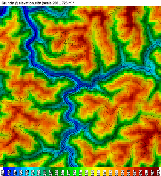
Below is the Elevation map of Grundy, which displays elevation range with different colors. Scale of the first map is from 296 to 723 m (971 to 2372 ft) with average elevation of 526.2 meters (=1726 ft) [note 1]
These maps also provides idea of topography and contour of this city, they are displayed at different zoom levels. More info about maps, scale and edge coordinates you can find below images.
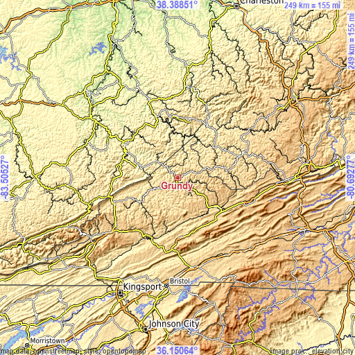
| \ | Map #1 | Topo.Map |
| Scale [m] | 296..723 m | × |
| Scale [ft] | 971..2372 ft | × |
| Average | 526.2 m = 1726 ft | × |
| Width | 7.78 km = 4.8 mi | 248.8 km = 154.6 mi |
| Height | 7.78 km = 4.8 mi | 248.8 km = 154.6 mi |
| ↑Max Latitude | 37.312849° | 38.38851° |
| Latitude at center | 37.27789° | 37.27789° |
| ↓Min Latitude | 37.242914° | 36.15064° |
| ← Min Longitude | -82.142965° | -83.50527° |
| Longitude center | -82.09902° | -82.09902° |
| →Max Longitude | -82.055075° | -80.69277° |
Nearby cities:
Cities around Grundy sort by population:
• Pikeville elevation 209 m
43.3 km,  301°
301°
• Richlands 588 m
34 km,  127°
127°
• Lebanon 627 m
41.9 km,  177°
177°
• Williamson 200 m
46.8 km,  340°
340°
• Raven 581 m
30.3 km, 134°
• Castlewood 491 m
46 km,  200°
200°
• Claypool Hill 710 m
39 km, 127°
• Coal Run Village 207 m
48.3 km, 302°
• Honaker 581 m
31.1 km,  159°
159°
• Clintwood 538 m
34.7 km,  245°
245°
• Gilbert Creek 346 m
37.7 km,  28°
28°
• Cedar Bluff 601 m
36.8 km, 125°
Multilingual:
 En español:
Grundy elevación 328 m.
 En France:
Grundy élévation 328 m.


Sources and notes:
- [note 1] Map square and city borders are not equal. Map elevation data is calculated only from area inside that square.
- [src 1] Elevation data from geonames database provided with same terms of usage.
- [src 2] The elevation map of Grundy is generated using elevation data from NASA's 3 arcsec (90m) resolution SRTM data.
- [src 3] Base (background) map © OpenStreetMap contributors tiles are generated by Geofabrik and OpenTopoMap.
Copyright & License:
This Grundy Elevation Map is licensed under CC BY-SA. You may reuse any part from this page, if you give a proper credit by linking to this URL:
 More info on terms of use page.