Arlington elevation
Arlington (Virginia, Arlington County), United States elevation is 83 meters and Arlington elevation in feet is 272 ft above sea level [src 1]. Arlington is a seat of a second-order administrative division (feature code) with elevation that is 196 meters (643 ft) smaller than average city elevation in United States.
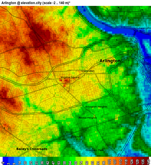
Below is the Elevation map of Arlington, which displays elevation range with different colors. Scale of the first map is from -2 to 140 m (-7 to 459 ft) with average elevation of 71.2 meters (=234 ft) [note 1]
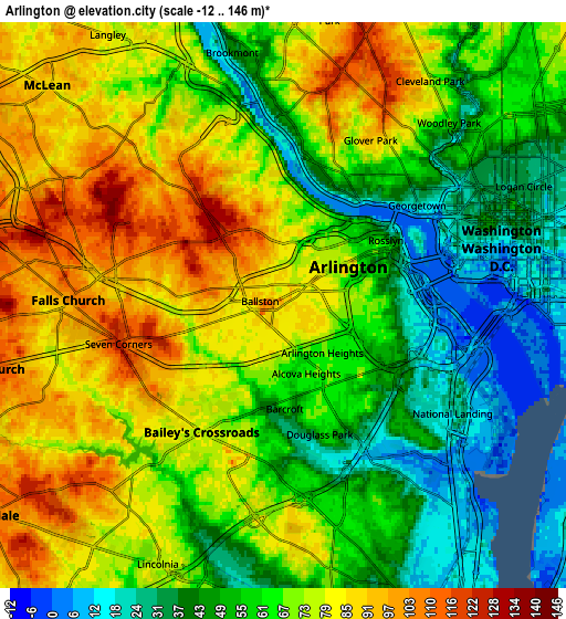
These maps also provides idea of topography and contour of this city, they are displayed at different zoom levels. More info about maps, scale and edge coordinates you can find below images.
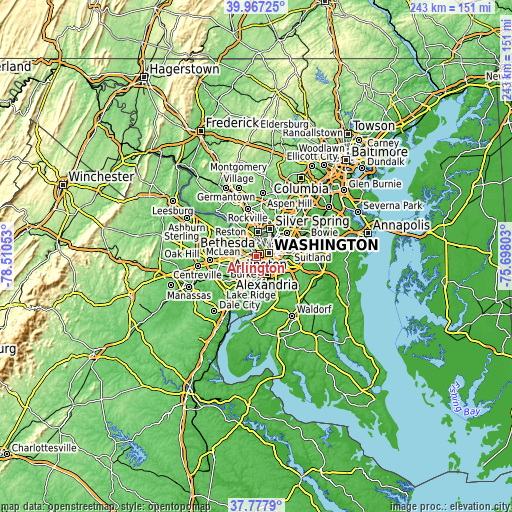
| \ | Map #1 | Map #2 | Topo.Map |
| Scale [m] | -2..140 m | -12..146 m | × |
| Scale [ft] | -7..459 ft | -39..479 ft | × |
| Average | 71.2 m = 234 ft | 66.3 m = 218 ft | × |
| Width | 7.61 km = 4.7 mi | 15.21 km = 9.5 mi | 243.4 km = 151.2 mi |
| Height | 7.61 km = 4.7 mi | 15.21 km = 9.5 mi | 243.4 km = 151.2 mi |
| ↑Max Latitude | 38.915211° | 38.949396° | 39.96725° |
| Latitude at center | 38.88101° | 38.88101° | 38.88101° |
| ↓Min Latitude | 38.846792° | 38.812559° | 37.7779° |
| ← Min Longitude | -77.148225° | -77.192171° | -78.51053° |
| Longitude center | -77.10428° | -77.10428° | -77.10428° |
| →Max Longitude | -77.060335° | -77.016389° | -75.69803° |
Nearby cities:
Cities around Arlington sort by population:
• Washington, D.C. elevation 6 m
6.1 km,  75°
75°
• West Falls Church 104 m
7 km,  279°
279°
• Jefferson 106 m
7.5 km,  255°
255°
• Baileys Crossroads 77 m
4.1 km,  212°
212°
• Lincolnia 74 m
7.7 km, 205°
• Shaw 30 m
8 km,  64°
64°
• Adams Morgan 55 m
7 km,  50°
50°
• Falls Church 104 m
5.8 km,  271°
271°
• Rosslyn 37 m
3.3 km, 57°
• Lake Barcroft 84 m
5.8 km,  230°
230°
• Seven Corners 119 m
4.5 km, 257°
• Brookmont 42 m
6.9 km,  348°
348°
Multilingual:
 En español:
Arlington elevación 83 m.
 En France:
Arlington élévation 83 m.
 Auf Deutsch:
Arlington höhe über dem Meeresspiegel ist 83 m.

Sources and notes:
- [note 1] Map square and city borders are not equal. Map elevation data is calculated only from area inside that square.
- [src 1] Elevation data from geonames database provided with same terms of usage.
- [src 2] The elevation map of Arlington is generated using elevation data from NASA's 3 arcsec (90m) resolution SRTM data.
- [src 3] Base (background) map © OpenStreetMap contributors tiles are generated by Geofabrik and OpenTopoMap.
Copyright & License:
This Arlington Elevation Map is licensed under CC BY-SA. You may reuse any part from this page, if you give a proper credit by linking to this URL:
 More info on terms of use page.