Zapata elevation
Zapata (Texas, Zapata County), United States elevation is 123 meters and Zapata elevation in feet is 404 ft above sea level [src 1]. Zapata is a seat of a second-order administrative division (feature code) with elevation that is 156 meters (512 ft) smaller than average city elevation in United States.
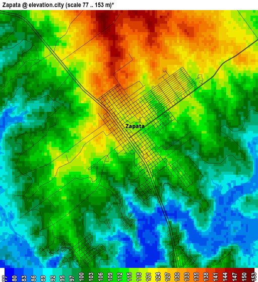
Below is the Elevation map of Zapata, which displays elevation range with different colors. Scale of the first map is from 77 to 153 m (253 to 502 ft) with average elevation of 108.8 meters (=357 ft) [note 1]
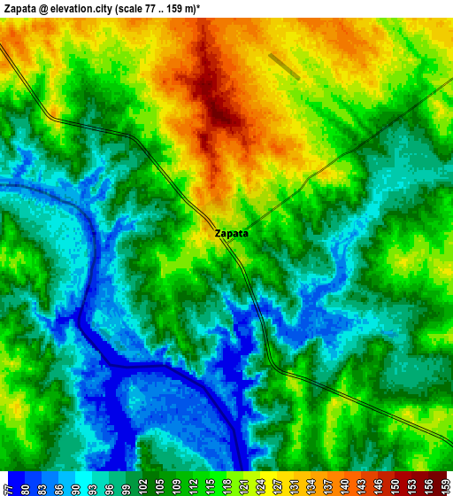
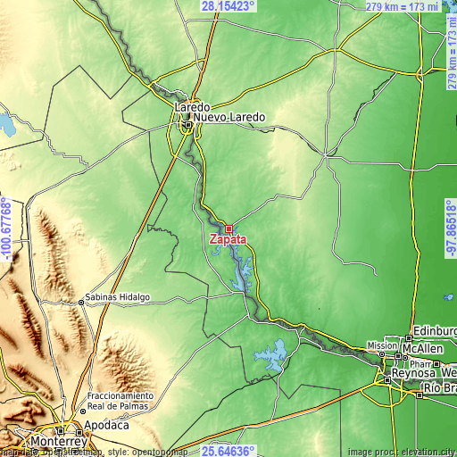
These maps also provides idea of topography and contour of this city, they are displayed at different zoom levels. More info about maps, scale and edge coordinates you can find below images.
| \ | Map #1 | Map #2 | Topo.Map |
| Scale [m] | 77..153 m | 77..159 m | × |
| Scale [ft] | 253..502 ft | 253..522 ft | × |
| Average | 108.8 m = 357 ft | 108.6 m = 356 ft | × |
| Width | 8.71 km = 5.4 mi | 17.43 km = 10.8 mi | 278.8 km = 173.2 mi |
| Height | 8.71 km = 5.4 mi | 17.43 km = 10.8 mi | 278.9 km = 173.3 mi |
| ↑Max Latitude | 26.946441° | 26.985608° | 28.15423° |
| Latitude at center | 26.90726° | 26.90726° | 26.90726° |
| ↓Min Latitude | 26.868065° | 26.828857° | 25.64636° |
| ← Min Longitude | -99.315375° | -99.359321° | -100.67768° |
| Longitude center | -99.27143° | -99.27143° | -99.27143° |
| →Max Longitude | -99.227485° | -99.183539° | -97.86518° |
Nearby cities:
Cities around Zapata sort by population:
• Laredo elevation 132 m
70.6 km,  340°
340°
• Rio Grande City 57 m
73.8 km,  142°
142°
• Roma 67 m
61.3 km,  155°
155°
• Roma-Los Saenz 67 m
61.3 km, 155°
• Rio Bravo 125 m
54.8 km, 337°
• Hebbronville 174 m
73.5 km,  52°
52°
• Medina 123 m
1.9 km,  37°
37°
• El Cenizo 117 m
54.1 km, 336°
• Las Lomas 59 m
77.9 km, 140°
• Escobares 56 m
63.2 km,  150°
150°
• Siesta Shores 113 m
5.7 km, 162°
• Falcon Lake Estates 109 m
4.1 km, 157°
Multilingual:
 En español:
Zapata elevación 123 m.
 En France:
Zapata élévation 123 m.


Sources and notes:
- [note 1] Map square and city borders are not equal. Map elevation data is calculated only from area inside that square.
- [src 1] Elevation data from geonames database provided with same terms of usage.
- [src 2] The elevation map of Zapata is generated using elevation data from NASA's 3 arcsec (90m) resolution SRTM data.
- [src 3] Base (background) map © OpenStreetMap contributors tiles are generated by Geofabrik and OpenTopoMap.
Copyright & License:
This Zapata Elevation Map is licensed under CC BY-SA. You may reuse any part from this page, if you give a proper credit by linking to this URL:
 More info on terms of use page.