Las Lomas elevation
Las Lomas (Texas, Starr County), United States elevation is 59 meters and Las Lomas elevation in feet is 194 ft above sea level [src 1]. Las Lomas is a populated place (feature code) with elevation that is 220 meters (722 ft) smaller than average city elevation in United States.
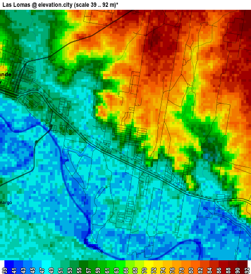
Below is the Elevation map of Las Lomas, which displays elevation range with different colors. Scale of the first map is from 39 to 92 m (128 to 302 ft) with average elevation of 60.1 meters (=197 ft) [note 1]
These maps also provides idea of topography and contour of this city, they are displayed at different zoom levels. More info about maps, scale and edge coordinates you can find below images.
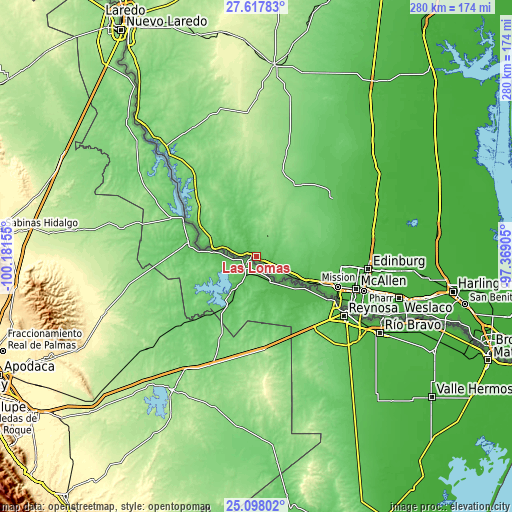
| \ | Map #1 | Topo.Map |
| Scale [m] | 39..92 m | × |
| Scale [ft] | 128..302 ft | × |
| Average | 60.1 m = 197 ft | × |
| Width | 8.76 km = 5.4 mi | 280.2 km = 174.1 mi |
| Height | 8.76 km = 5.4 mi | 280.2 km = 174.1 mi |
| ↑Max Latitude | 26.404158° | 27.61783° |
| Latitude at center | 26.36479° | 26.36479° |
| ↓Min Latitude | 26.325409° | 25.09802° |
| ← Min Longitude | -98.819245° | -100.18155° |
| Longitude center | -98.7753° | -98.7753° |
| →Max Longitude | -98.731355° | -97.36905° |
Nearby cities:
Cities around Las Lomas sort by population:
• Rio Grande City elevation 57 m
4.8 km,  290°
290°
• Roma 67 m
24.4 km,  280°
280°
• Roma-Los Saenz 67 m
24.4 km, 280°
• Perezville 41 m
40.5 km,  112°
112°
• Doffing 60 m
40.1 km,  104°
104°
• Penitas 48 m
36.2 km, 114°
• La Joya 57 m
32.1 km, 114°
• Sullivan City 67 m
23.2 km, 114°
• Escobares 56 m
19.3 km, 285°
• Citrus City 68 m
39.1 km, 96°
• Abram 39 m
40.7 km,  116°
116°
• La Grulla 46 m
16.6 km,  129°
129°
Multilingual:
 En español:
Las Lomas elevación 59 m.
 En France:
Las Lomas élévation 59 m.
 Auf Deutsch:
Las Lomas höhe über dem Meeresspiegel ist 59 m.

Sources and notes:
- [note 1] Map square and city borders are not equal. Map elevation data is calculated only from area inside that square.
- [src 1] Elevation data from geonames database provided with same terms of usage.
- [src 2] The elevation map of Las Lomas is generated using elevation data from NASA's 3 arcsec (90m) resolution SRTM data.
- [src 3] Base (background) map © OpenStreetMap contributors tiles are generated by Geofabrik and OpenTopoMap.
Copyright & License:
This Las Lomas Elevation Map is licensed under CC BY-SA. You may reuse any part from this page, if you give a proper credit by linking to this URL:
 More info on terms of use page.