Weatherford elevation
Weatherford (Texas, Parker County), United States elevation is 328 meters and Weatherford elevation in feet is 1076 ft above sea level [src 1]. Weatherford is a seat of a second-order administrative division (feature code) with elevation that is 49 meters (161 ft) bigger than average city elevation in United States.
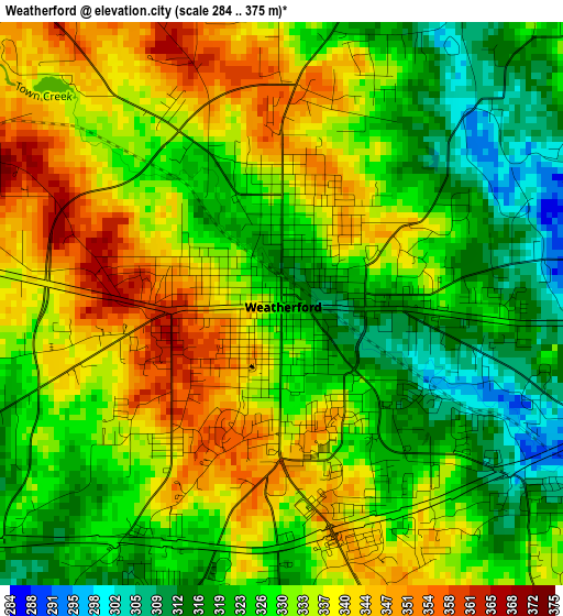
Below is the Elevation map of Weatherford, which displays elevation range with different colors. Scale of the first map is from 284 to 375 m (932 to 1230 ft) with average elevation of 330.1 meters (=1083 ft) [note 1]
These maps also provides idea of topography and contour of this city, they are displayed at different zoom levels. More info about maps, scale and edge coordinates you can find below images.
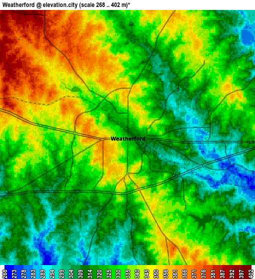
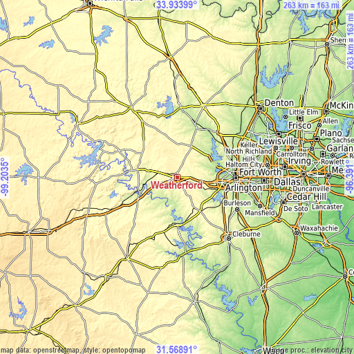
| \ | Map #1 | Map #2 | Topo.Map |
| Scale [m] | 284..375 m | 268..402 m | × |
| Scale [ft] | 932..1230 ft | 879..1319 ft | × |
| Average | 330.1 m = 1083 ft | 328.7 m = 1078 ft | × |
| Width | 8.22 km = 5.1 mi | 16.44 km = 10.2 mi | 263 km = 163.4 mi |
| Height | 8.22 km = 5.1 mi | 16.44 km = 10.2 mi | 263 km = 163.4 mi |
| ↑Max Latitude | 32.796248° | 32.833181° | 33.93399° |
| Latitude at center | 32.7593° | 32.7593° | 32.7593° |
| ↓Min Latitude | 32.722336° | 32.685358° | 31.56891° |
| ← Min Longitude | -97.841195° | -97.885141° | -99.2035° |
| Longitude center | -97.79725° | -97.79725° | -97.79725° |
| →Max Longitude | -97.753305° | -97.709359° | -96.391° |
Nearby cities:
Cities around Weatherford sort by population:
• Mineral Wells elevation 273 m
30 km,  280°
280°
• Azle 219 m
27.9 km,  57°
57°
• Willow Park 293 m
13.7 km,  88°
88°
• Aledo 273 m
19.6 km,  111°
111°
• Springtown 265 m
25.3 km,  24°
24°
• Oak Trail Shores 253 m
30.3 km,  186°
186°
• Reno 227 m
29.1 km,  44°
44°
• Hudson Oaks 320 m
8.5 km, 91°
• Pelican Bay 219 m
31.7 km, 55°
• Western Lake 243 m
15.2 km, 185°
• Annetta 274 m
12.6 km,  116°
116°
• Lakeside 226 m
29.3 km,  76°
76°
Multilingual:
 En español:
Weatherford elevación 328 m.
 En France:
Weatherford élévation 328 m.
 Auf Deutsch:
Weatherford höhe über dem Meeresspiegel ist 328 m.

Sources and notes:
- [note 1] Map square and city borders are not equal. Map elevation data is calculated only from area inside that square.
- [src 1] Elevation data from geonames database provided with same terms of usage.
- [src 2] The elevation map of Weatherford is generated using elevation data from NASA's 3 arcsec (90m) resolution SRTM data.
- [src 3] Base (background) map © OpenStreetMap contributors tiles are generated by Geofabrik and OpenTopoMap.
Copyright & License:
This Weatherford Elevation Map is licensed under CC BY-SA. You may reuse any part from this page, if you give a proper credit by linking to this URL:
 More info on terms of use page.