Hudson Oaks elevation
Hudson Oaks (Texas, Parker County), United States elevation is 320 meters and Hudson Oaks elevation in feet is 1050 ft above sea level [src 1]. Hudson Oaks is a populated place (feature code) with elevation that is 41 meters (135 ft) bigger than average city elevation in United States.
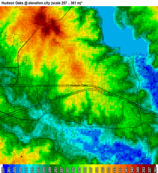
Below is the Elevation map of Hudson Oaks, which displays elevation range with different colors. Scale of the first map is from 257 to 361 m (843 to 1184 ft) with average elevation of 298.7 meters (=980 ft) [note 1]
These maps also provides idea of topography and contour of this city, they are displayed at different zoom levels. More info about maps, scale and edge coordinates you can find below images.
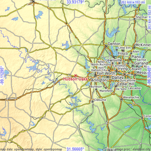
| \ | Map #1 | Topo.Map |
| Scale [m] | 257..361 m | × |
| Scale [ft] | 843..1184 ft | × |
| Average | 298.7 m = 980 ft | × |
| Width | 8.22 km = 5.1 mi | 263 km = 163.4 mi |
| Height | 8.22 km = 5.1 mi | 263 km = 163.4 mi |
| ↑Max Latitude | 32.794019° | 33.93179° |
| Latitude at center | 32.75707° | 32.75707° |
| ↓Min Latitude | 32.720106° | 31.56665° |
| ← Min Longitude | -97.750645° | -99.11295° |
| Longitude center | -97.7067° | -97.7067° |
| →Max Longitude | -97.662755° | -96.30045° |
Nearby cities:
Cities around Hudson Oaks sort by population:
• Weatherford elevation 328 m
8.5 km,  271°
271°
• Benbrook 213 m
24.8 km,  112°
112°
• White Settlement 207 m
23.2 km,  89°
89°
• Azle 219 m
21.5 km,  44°
44°
• Willow Park 293 m
5.3 km,  83°
83°
• Lake Worth 201 m
25 km, 77°
• Aledo 273 m
11.9 km,  124°
124°
• Springtown 265 m
23.3 km,  5°
5°
• Reno 227 m
24.1 km,  30°
30°
• Western Lake 243 m
17.8 km,  213°
213°
• Annetta 274 m
6 km,  151°
151°
• Lakeside 226 m
21.2 km,  70°
70°
Multilingual:
 En español:
Hudson Oaks elevación 320 m.
 En France:
Hudson Oaks élévation 320 m.
 Auf Deutsch:
Hudson Oaks höhe über dem Meeresspiegel ist 320 m.

Sources and notes:
- [note 1] Map square and city borders are not equal. Map elevation data is calculated only from area inside that square.
- [src 1] Elevation data from geonames database provided with same terms of usage.
- [src 2] The elevation map of Hudson Oaks is generated using elevation data from NASA's 3 arcsec (90m) resolution SRTM data.
- [src 3] Base (background) map © OpenStreetMap contributors tiles are generated by Geofabrik and OpenTopoMap.
Copyright & License:
This Hudson Oaks Elevation Map is licensed under CC BY-SA. You may reuse any part from this page, if you give a proper credit by linking to this URL:
 More info on terms of use page.