Three Rivers elevation
Three Rivers (Texas, Live Oak County), United States elevation is 48 meters and Three Rivers elevation in feet is 157 ft above sea level [src 1]. Three Rivers is a populated place (feature code) with elevation that is 231 meters (758 ft) smaller than average city elevation in United States.
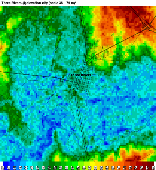
Below is the Elevation map of Three Rivers, which displays elevation range with different colors. Scale of the first map is from 38 to 79 m (125 to 259 ft) with average elevation of 50.4 meters (=165 ft) [note 1]
These maps also provides idea of topography and contour of this city, they are displayed at different zoom levels. More info about maps, scale and edge coordinates you can find below images.
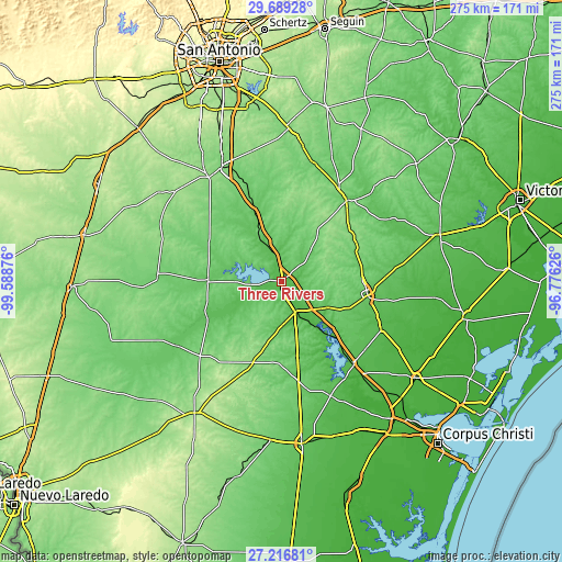
| \ | Map #1 | Topo.Map |
| Scale [m] | 38..79 m | × |
| Scale [ft] | 125..259 ft | × |
| Average | 50.4 m = 165 ft | × |
| Width | 8.59 km = 5.3 mi | 274.9 km = 170.8 mi |
| Height | 8.59 km = 5.3 mi | 274.9 km = 170.8 mi |
| ↑Max Latitude | 28.498897° | 29.68928° |
| Latitude at center | 28.46027° | 28.46027° |
| ↓Min Latitude | 28.421629° | 27.21681° |
| ← Min Longitude | -98.226455° | -99.58876° |
| Longitude center | -98.18251° | -98.18251° |
| →Max Longitude | -98.138565° | -96.77626° |
Nearby cities:
Cities around Three Rivers sort by population:
• Beeville elevation 70 m
42.8 km,  98°
98°
• Pleasanton 115 m
63.3 km,  332°
332°
• Mathis 53 m
53.5 km,  139°
139°
• Jourdanton 143 m
62.1 km, 325°
• Kenedy 85 m
51.5 km,  39°
39°
• Karnes City 133 m
54.6 km,  30°
30°
• George West 51 m
15.6 km,  155°
155°
• Poth 125 m
68.5 km,  8°
8°
• Charlotte 167 m
67.9 km,  311°
311°
• Orange Grove 62 m
60.9 km, 156°
• Runge 97 m
65.7 km, 44°
• Tilden 79 m
35.8 km,  270°
270°
Multilingual:
 En español:
Three Rivers elevación 48 m.
 En France:
Three Rivers élévation 48 m.
 Auf Deutsch:
Three Rivers höhe über dem Meeresspiegel ist 48 m.

Sources and notes:
- [note 1] Map square and city borders are not equal. Map elevation data is calculated only from area inside that square.
- [src 1] Elevation data from geonames database provided with same terms of usage.
- [src 2] The elevation map of Three Rivers is generated using elevation data from NASA's 3 arcsec (90m) resolution SRTM data.
- [src 3] Base (background) map © OpenStreetMap contributors tiles are generated by Geofabrik and OpenTopoMap.
Copyright & License:
This Three Rivers Elevation Map is licensed under CC BY-SA. You may reuse any part from this page, if you give a proper credit by linking to this URL:
 More info on terms of use page.