Mathis elevation
Mathis (Texas, San Patricio County), United States elevation is 53 meters and Mathis elevation in feet is 174 ft above sea level [src 1]. Mathis is a populated place (feature code) with elevation that is 226 meters (741 ft) smaller than average city elevation in United States.
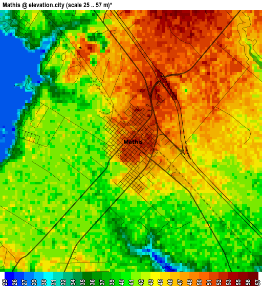
Below is the Elevation map of Mathis, which displays elevation range with different colors. Scale of the first map is from 25 to 57 m (82 to 187 ft) with average elevation of 43.1 meters (=141 ft) [note 1]
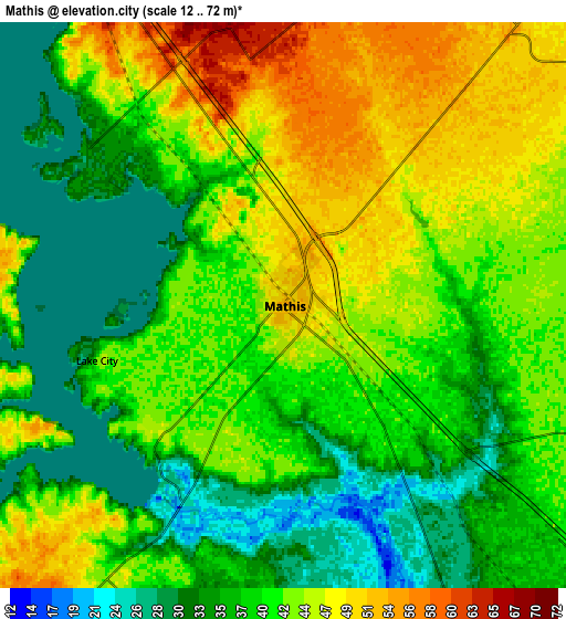
These maps also provides idea of topography and contour of this city, they are displayed at different zoom levels. More info about maps, scale and edge coordinates you can find below images.
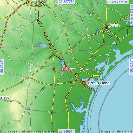
| \ | Map #1 | Map #2 | Topo.Map |
| Scale [m] | 25..57 m | 12..72 m | × |
| Scale [ft] | 82..187 ft | 39..236 ft | × |
| Average | 43.1 m = 141 ft | 40.5 m = 133 ft | × |
| Width | 8.62 km = 5.4 mi | 17.24 km = 10.7 mi | 275.9 km = 171.4 mi |
| Height | 8.62 km = 5.4 mi | 17.24 km = 10.7 mi | 275.9 km = 171.4 mi |
| ↑Max Latitude | 28.13322° | 28.171967° | 29.32778° |
| Latitude at center | 28.09446° | 28.09446° | 28.09446° |
| ↓Min Latitude | 28.055686° | 28.016897° | 26.84681° |
| ← Min Longitude | -97.871995° | -97.915941° | -99.2343° |
| Longitude center | -97.82805° | -97.82805° | -97.82805° |
| →Max Longitude | -97.784105° | -97.740159° | -96.4218° |
Nearby cities:
Cities around Mathis sort by population:
• Corpus Christi elevation 8 m
53.5 km,  127°
127°
• Alice 70 m
44.9 km,  211°
211°
• Beeville 70 m
34.9 km,  12°
12°
• Robstown 26 m
37.3 km,  155°
155°
• Sinton 19 m
31.9 km,  101°
101°
• Taft 20 m
44.1 km,  106°
106°
• George West 51 m
38.8 km,  313°
313°
• Odem 27 m
29 km,  123°
123°
• Rancho Alegre 72 m
47.2 km, 213°
• Woodsboro 18 m
52.3 km,  72°
72°
• Taft Southwest (historical) 23 m
43.8 km, 107°
• Orange Grove 62 m
18.7 km, 214°
Multilingual:
 En español:
Mathis elevación 53 m.
 En France:
Mathis élévation 53 m.


Sources and notes:
- [note 1] Map square and city borders are not equal. Map elevation data is calculated only from area inside that square.
- [src 1] Elevation data from geonames database provided with same terms of usage.
- [src 2] The elevation map of Mathis is generated using elevation data from NASA's 3 arcsec (90m) resolution SRTM data.
- [src 3] Base (background) map © OpenStreetMap contributors tiles are generated by Geofabrik and OpenTopoMap.
Copyright & License:
This Mathis Elevation Map is licensed under CC BY-SA. You may reuse any part from this page, if you give a proper credit by linking to this URL:
 More info on terms of use page.