San Augustine elevation
San Augustine (Texas, San Augustine County), United States elevation is 121 meters and San Augustine elevation in feet is 397 ft above sea level [src 1]. San Augustine is a seat of a second-order administrative division (feature code) with elevation that is 158 meters (518 ft) smaller than average city elevation in United States.
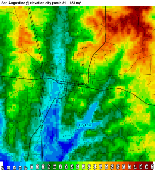
Below is the Elevation map of San Augustine, which displays elevation range with different colors. Scale of the first map is from 81 to 183 m (266 to 600 ft) with average elevation of 125.1 meters (=410 ft) [note 1]
These maps also provides idea of topography and contour of this city, they are displayed at different zoom levels. More info about maps, scale and edge coordinates you can find below images.
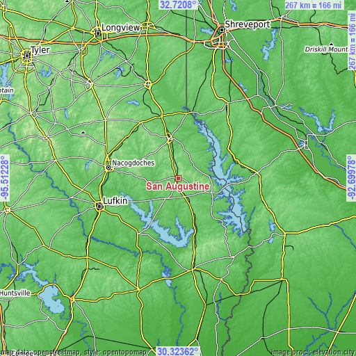
| \ | Map #1 | Topo.Map |
| Scale [m] | 81..183 m | × |
| Scale [ft] | 266..600 ft | × |
| Average | 125.1 m = 410 ft | × |
| Width | 8.33 km = 5.2 mi | 266.5 km = 165.6 mi |
| Height | 8.33 km = 5.2 mi | 266.5 km = 165.6 mi |
| ↑Max Latitude | 31.56735° | 32.7208° |
| Latitude at center | 31.5299° | 31.5299° |
| ↓Min Latitude | 31.492435° | 30.32362° |
| ← Min Longitude | -94.149975° | -95.51228° |
| Longitude center | -94.10603° | -94.10603° |
| →Max Longitude | -94.062085° | -92.69978° |
Nearby cities:
Cities around San Augustine sort by population:
• Nacogdoches elevation 95 m
52.7 km,  278°
278°
• Center 118 m
30.3 km,  346°
346°
• Many 85 m
59.1 km,  85°
85°
• Huntington 103 m
52.7 km,  237°
237°
• Zwolle 64 m
45.2 km,  75°
75°
• Logansport 71 m
50.6 km,  11°
11°
• Milam 100 m
27 km,  113°
113°
• Hemphill 93 m
32.4 km,  130°
130°
• Sam Rayburn 67 m
52.2 km,  172°
172°
• Tenaha 111 m
47.8 km,  344°
344°
• Timpson 122 m
49.8 km,  326°
326°
• Redland 111 m
60 km,  256°
256°
Multilingual:
 En español:
San Augustine elevación 121 m.
 En France:
San Augustine élévation 121 m.
 Auf Deutsch:
San Augustine höhe über dem Meeresspiegel ist 121 m.

Sources and notes:
- [note 1] Map square and city borders are not equal. Map elevation data is calculated only from area inside that square.
- [src 1] Elevation data from geonames database provided with same terms of usage.
- [src 2] The elevation map of San Augustine is generated using elevation data from NASA's 3 arcsec (90m) resolution SRTM data.
- [src 3] Base (background) map © OpenStreetMap contributors tiles are generated by Geofabrik and OpenTopoMap.
Copyright & License:
This San Augustine Elevation Map is licensed under CC BY-SA. You may reuse any part from this page, if you give a proper credit by linking to this URL:
 More info on terms of use page.