Hemphill elevation
Hemphill (Texas, Sabine County), United States elevation is 93 meters and Hemphill elevation in feet is 305 ft above sea level [src 1]. Hemphill is a seat of a second-order administrative division (feature code) with elevation that is 186 meters (610 ft) smaller than average city elevation in United States.
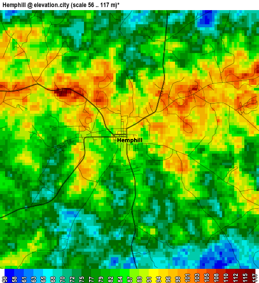
Below is the Elevation map of Hemphill, which displays elevation range with different colors. Scale of the first map is from 56 to 117 m (184 to 384 ft) with average elevation of 83.4 meters (=274 ft) [note 1]
These maps also provides idea of topography and contour of this city, they are displayed at different zoom levels. More info about maps, scale and edge coordinates you can find below images.
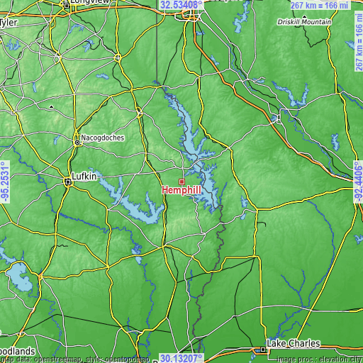
| \ | Map #1 | Topo.Map |
| Scale [m] | 56..117 m | × |
| Scale [ft] | 184..384 ft | × |
| Average | 83.4 m = 274 ft | × |
| Width | 8.35 km = 5.2 mi | 267.1 km = 166 mi |
| Height | 8.35 km = 5.2 mi | 267.1 km = 166 mi |
| ↑Max Latitude | 31.378266° | 32.53408° |
| Latitude at center | 31.34074° | 31.34074° |
| ↓Min Latitude | 31.303199° | 30.13207° |
| ← Min Longitude | -93.890795° | -95.2531° |
| Longitude center | -93.84685° | -93.84685° |
| →Max Longitude | -93.802905° | -92.4406° |
Nearby cities:
Cities around Hemphill sort by population:
• Fort Polk South elevation 92 m
68.1 km,  118°
118°
• Jasper 65 m
48.9 km,  196°
196°
• Leesville 81 m
59.9 km,  111°
111°
• Center 118 m
59.6 km,  328°
328°
• Fort Polk North 118 m
68.8 km, 112°
• Many 85 m
42.7 km,  53°
53°
• New Llano 70 m
60.2 km, 114°
• Newton 62 m
55.4 km,  171°
171°
• San Augustine 121 m
32.4 km,  310°
310°
• Zwolle 64 m
37.6 km,  30°
30°
• Milam 100 m
10.2 km,  0°
0°
• Sam Rayburn 67 m
35.6 km,  210°
210°
Multilingual:
 En español:
Hemphill elevación 93 m.
 En France:
Hemphill élévation 93 m.


Sources and notes:
- [note 1] Map square and city borders are not equal. Map elevation data is calculated only from area inside that square.
- [src 1] Elevation data from geonames database provided with same terms of usage.
- [src 2] The elevation map of Hemphill is generated using elevation data from NASA's 3 arcsec (90m) resolution SRTM data.
- [src 3] Base (background) map © OpenStreetMap contributors tiles are generated by Geofabrik and OpenTopoMap.
Copyright & License:
This Hemphill Elevation Map is licensed under CC BY-SA. You may reuse any part from this page, if you give a proper credit by linking to this URL:
 More info on terms of use page.