Madisonville elevation
Madisonville (Texas, Madison County), United States elevation is 78 meters and Madisonville elevation in feet is 256 ft above sea level [src 1]. Madisonville is a seat of a second-order administrative division (feature code) with elevation that is 201 meters (659 ft) smaller than average city elevation in United States.
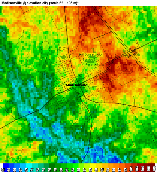
Below is the Elevation map of Madisonville, which displays elevation range with different colors. Scale of the first map is from 62 to 108 m (203 to 354 ft) with average elevation of 85.4 meters (=280 ft) [note 1]
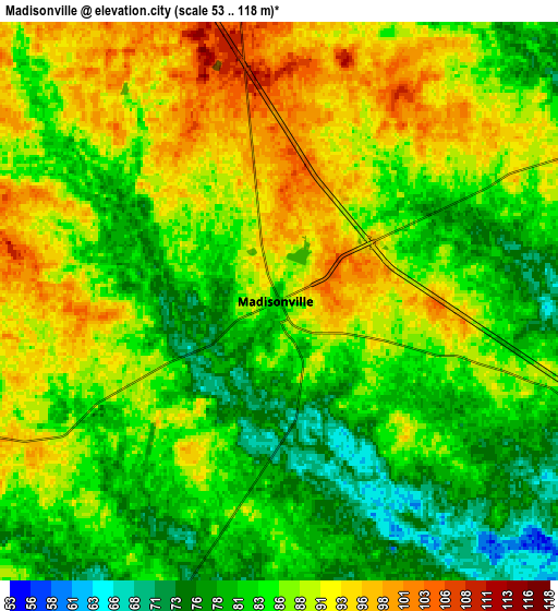
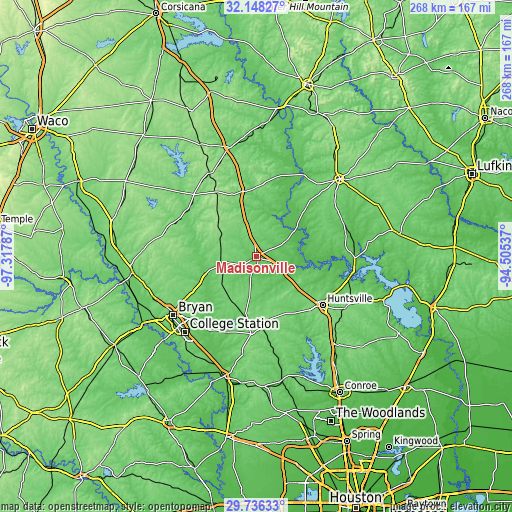
These maps also provides idea of topography and contour of this city, they are displayed at different zoom levels. More info about maps, scale and edge coordinates you can find below images.
| \ | Map #1 | Map #2 | Topo.Map |
| Scale [m] | 62..108 m | 53..118 m | × |
| Scale [ft] | 203..354 ft | 174..387 ft | × |
| Average | 85.4 m = 280 ft | 85.6 m = 281 ft | × |
| Width | 8.38 km = 5.2 mi | 16.76 km = 10.4 mi | 268.2 km = 166.7 mi |
| Height | 8.38 km = 5.2 mi | 16.76 km = 10.4 mi | 268.2 km = 166.7 mi |
| ↑Max Latitude | 30.987591° | 31.025257° | 32.14827° |
| Latitude at center | 30.94991° | 30.94991° | 30.94991° |
| ↓Min Latitude | 30.912214° | 30.874504° | 29.73633° |
| ← Min Longitude | -95.955565° | -95.999511° | -97.31787° |
| Longitude center | -95.91162° | -95.91162° | -95.91162° |
| →Max Longitude | -95.867675° | -95.823729° | -94.50537° |
Nearby cities:
Cities around Madisonville sort by population:
• College Station elevation 107 m
54 km,  228°
228°
• Bryan 116 m
53.4 km,  235°
235°
• Huntsville 116 m
42.7 km,  126°
126°
• Crockett 116 m
59.6 km,  46°
46°
• Trinity 74 m
51.1 km,  90°
90°
• Cooper 81 m
45.3 km,  43°
43°
• Buffalo 120 m
58.8 km,  346°
346°
• Franklin 137 m
55.3 km,  278°
278°
• Jewett 152 m
50.8 km,  334°
334°
• Hilltop Lakes 146 m
31.3 km,  297°
297°
• Centerville 109 m
34.8 km, 349°
• Anderson 110 m
52 km,  187°
187°
Multilingual:
 En español:
Madisonville elevación 78 m.
 En France:
Madisonville élévation 78 m.
 Auf Deutsch:
Madisonville höhe über dem Meeresspiegel ist 78 m.

Sources and notes:
- [note 1] Map square and city borders are not equal. Map elevation data is calculated only from area inside that square.
- [src 1] Elevation data from geonames database provided with same terms of usage.
- [src 2] The elevation map of Madisonville is generated using elevation data from NASA's 3 arcsec (90m) resolution SRTM data.
- [src 3] Base (background) map © OpenStreetMap contributors tiles are generated by Geofabrik and OpenTopoMap.
Copyright & License:
This Madisonville Elevation Map is licensed under CC BY-SA. You may reuse any part from this page, if you give a proper credit by linking to this URL:
 More info on terms of use page.