Linden elevation
Linden (Texas, Cass County), United States elevation is 119 meters and Linden elevation in feet is 390 ft above sea level [src 1]. Linden is a seat of a second-order administrative division (feature code) with elevation that is 160 meters (525 ft) smaller than average city elevation in United States.
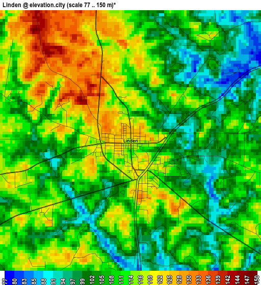
Below is the Elevation map of Linden, which displays elevation range with different colors. Scale of the first map is from 77 to 150 m (253 to 492 ft) with average elevation of 110.1 meters (=361 ft) [note 1]
These maps also provides idea of topography and contour of this city, they are displayed at different zoom levels. More info about maps, scale and edge coordinates you can find below images.

| \ | Map #1 | Topo.Map |
| Scale [m] | 77..150 m | × |
| Scale [ft] | 253..492 ft | × |
| Average | 110.1 m = 361 ft | × |
| Width | 8.19 km = 5.1 mi | 262.2 km = 162.9 mi |
| Height | 8.19 km = 5.1 mi | 262.2 km = 162.9 mi |
| ↑Max Latitude | 33.049193° | 34.18363° |
| Latitude at center | 33.01235° | 33.01235° |
| ↓Min Latitude | 32.975492° | 31.8253° |
| ← Min Longitude | -94.409415° | -95.77172° |
| Longitude center | -94.36547° | -94.36547° |
| →Max Longitude | -94.321525° | -92.95922° |
Nearby cities:
Cities around Linden sort by population:
• Atlanta elevation 83 m
21.9 km,  58°
58°
• New Boston 111 m
50 km,  354°
354°
• Vivian 81 m
38.6 km,  113°
113°
• Daingerfield 124 m
33.3 km,  273°
273°
• Jefferson 63 m
28.4 km,  176°
176°
• Hughes Springs 118 m
24.8 km, 266°
• Lone Star 112 m
32.8 km,  256°
256°
• Queen City 112 m
25.1 km,  52°
52°
• Naples 128 m
36.2 km,  305°
305°
• Ore City 104 m
40.7 km,  234°
234°
• Redwater 94 m
39.8 km,  15°
15°
• Maud 93 m
35.7 km,  3°
3°
Multilingual:
 En español:
Linden elevación 119 m.
 En France:
Linden élévation 119 m.


Sources and notes:
- [note 1] Map square and city borders are not equal. Map elevation data is calculated only from area inside that square.
- [src 1] Elevation data from geonames database provided with same terms of usage.
- [src 2] The elevation map of Linden is generated using elevation data from NASA's 3 arcsec (90m) resolution SRTM data.
- [src 3] Base (background) map © OpenStreetMap contributors tiles are generated by Geofabrik and OpenTopoMap.
Copyright & License:
This Linden Elevation Map is licensed under CC BY-SA. You may reuse any part from this page, if you give a proper credit by linking to this URL:
 More info on terms of use page.