Leakey elevation
Leakey (Texas, Real County), United States elevation is 494 meters and Leakey elevation in feet is 1621 ft above sea level [src 1]. Leakey is a seat of a second-order administrative division (feature code) with elevation that is 215 meters (705 ft) bigger than average city elevation in United States.
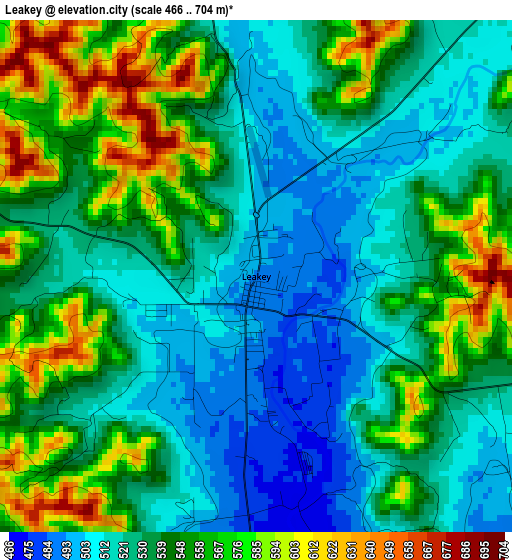
Below is the Elevation map of Leakey, which displays elevation range with different colors. Scale of the first map is from 466 to 704 m (1529 to 2310 ft) with average elevation of 539.1 meters (=1769 ft) [note 1]
These maps also provides idea of topography and contour of this city, they are displayed at different zoom levels. More info about maps, scale and edge coordinates you can find below images.
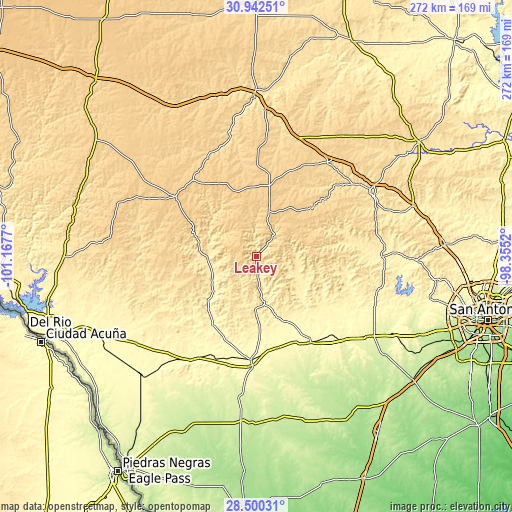
| \ | Map #1 | Topo.Map |
| Scale [m] | 466..704 m | × |
| Scale [ft] | 1529..2310 ft | × |
| Average | 539.1 m = 1769 ft | × |
| Width | 8.49 km = 5.3 mi | 271.5 km = 168.7 mi |
| Height | 8.49 km = 5.3 mi | 271.6 km = 168.8 mi |
| ↑Max Latitude | 29.766994° | 30.94251° |
| Latitude at center | 29.72884° | 29.72884° |
| ↓Min Latitude | 29.690671° | 28.50031° |
| ← Min Longitude | -99.805395° | -101.1677° |
| Longitude center | -99.76145° | -99.76145° |
| →Max Longitude | -99.717505° | -98.3552° |
Nearby cities:
Cities around Leakey sort by population:
• Kerrville elevation 501 m
69.6 km,  59°
59°
• Uvalde 281 m
57.8 km,  182°
182°
• Hondo 274 m
73.5 km,  125°
125°
• Lakehills 376 m
80.3 km,  99°
99°
• Medina 445 m
50.3 km,  81°
81°
• Uvalde Estates 290 m
63 km,  186°
186°
• Ingram 528 m
63.4 km,  52°
52°
• Sabinal 295 m
53.9 km,  148°
148°
• Brackettville 340 m
78.7 km,  233°
233°
• Fort Clark Springs 352 m
79.3 km, 233°
• Rocksprings 735 m
53.4 km,  306°
306°
• Bandera 382 m
66.4 km,  90°
90°
Multilingual:
 En español:
Leakey elevación 494 m.
 En France:
Leakey élévation 494 m.


Sources and notes:
- [note 1] Map square and city borders are not equal. Map elevation data is calculated only from area inside that square.
- [src 1] Elevation data from geonames database provided with same terms of usage.
- [src 2] The elevation map of Leakey is generated using elevation data from NASA's 3 arcsec (90m) resolution SRTM data.
- [src 3] Base (background) map © OpenStreetMap contributors tiles are generated by Geofabrik and OpenTopoMap.
Copyright & License:
This Leakey Elevation Map is licensed under CC BY-SA. You may reuse any part from this page, if you give a proper credit by linking to this URL:
 More info on terms of use page.