Hondo elevation
Hondo (Texas, Medina County), United States elevation is 274 meters and Hondo elevation in feet is 899 ft above sea level [src 1]. Hondo is a seat of a second-order administrative division (feature code) with elevation that is 5 meters (16 ft) smaller than average city elevation in United States.
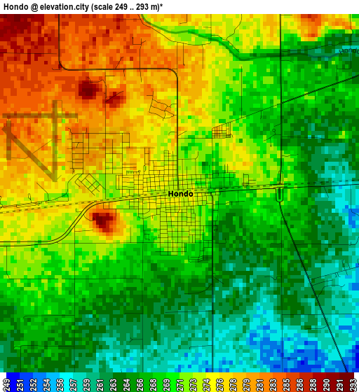
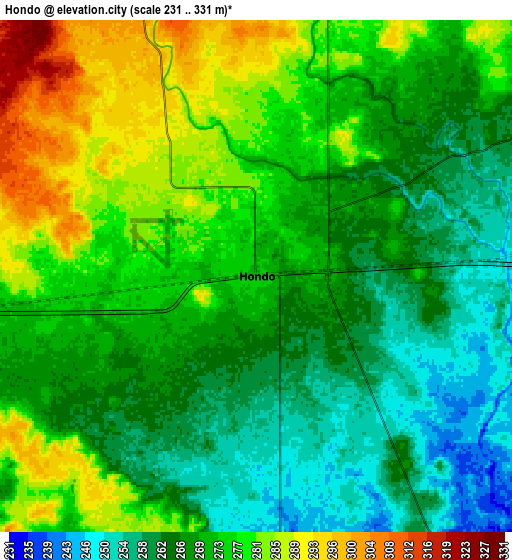
Below is the Elevation map of Hondo, which displays elevation range with different colors. Scale of the first map is from 249 to 293 m (817 to 961 ft) with average elevation of 270 meters (=886 ft) [note 1]
These maps also provides idea of topography and contour of this city, they are displayed at different zoom levels. More info about maps, scale and edge coordinates you can find below images.
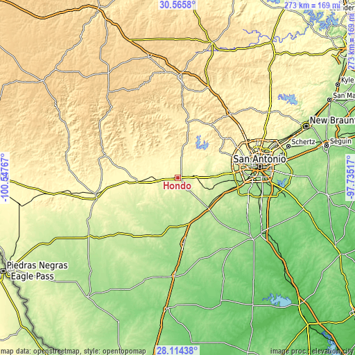
| \ | Map #1 | Map #2 | Topo.Map |
| Scale [m] | 249..293 m | 231..331 m | × |
| Scale [ft] | 817..961 ft | 758..1086 ft | × |
| Average | 270 m = 886 ft | 271 m = 889 ft | × |
| Width | 8.52 km = 5.3 mi | 17.04 km = 10.6 mi | 272.6 km = 169.4 mi |
| Height | 8.52 km = 5.3 mi | 17.04 km = 10.6 mi | 272.6 km = 169.4 mi |
| ↑Max Latitude | 29.385758° | 29.424042° | 30.5658° |
| Latitude at center | 29.34746° | 29.34746° | 29.34746° |
| ↓Min Latitude | 29.309147° | 29.27082° | 28.11438° |
| ← Min Longitude | -99.185365° | -99.229311° | -100.54767° |
| Longitude center | -99.14142° | -99.14142° | -99.14142° |
| →Max Longitude | -99.097475° | -99.053529° | -97.73517° |
Nearby cities:
Cities around Hondo sort by population:
• Pearsall elevation 193 m
50.8 km,  174°
174°
• Helotes 319 m
50.7 km,  59°
59°
• Lakehills 376 m
34.4 km,  33°
33°
• Devine 200 m
32.5 km,  135°
135°
• Castroville 234 m
25.5 km,  87°
87°
• Lytle 223 m
35.8 km,  110°
110°
• Somerset 199 m
48.8 km, 106°
• Sabinal 295 m
31.7 km,  263°
263°
• Natalia 211 m
32.2 km,  122°
122°
• Von Ormy 182 m
48.6 km,  97°
97°
• La Coste 222 m
32.4 km, 97°
• Bandera 382 m
42.7 km,  8°
8°
Multilingual:
 En español:
Hondo elevación 274 m.
 En France:
Hondo élévation 274 m.


Sources and notes:
- [note 1] Map square and city borders are not equal. Map elevation data is calculated only from area inside that square.
- [src 1] Elevation data from geonames database provided with same terms of usage.
- [src 2] The elevation map of Hondo is generated using elevation data from NASA's 3 arcsec (90m) resolution SRTM data.
- [src 3] Base (background) map © OpenStreetMap contributors tiles are generated by Geofabrik and OpenTopoMap.
Copyright & License:
This Hondo Elevation Map is licensed under CC BY-SA. You may reuse any part from this page, if you give a proper credit by linking to this URL:
 More info on terms of use page.