Lakeway elevation
Lakeway (Texas, Travis County), United States elevation is 228 meters and Lakeway elevation in feet is 748 ft above sea level [src 1]. Lakeway is a populated place (feature code) with elevation that is 51 meters (167 ft) smaller than average city elevation in United States.
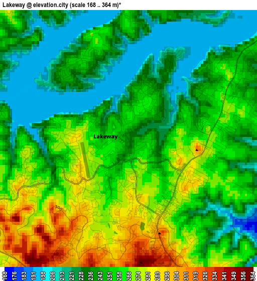
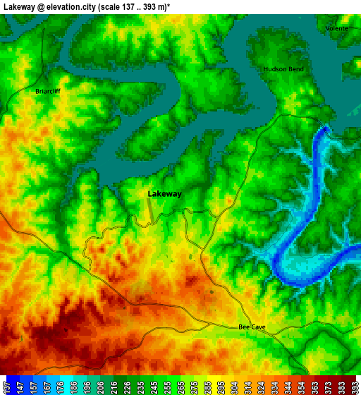
Below is the Elevation map of Lakeway, which displays elevation range with different colors. Scale of the first map is from 168 to 364 m (551 to 1194 ft) with average elevation of 250.7 meters (=823 ft) [note 1]
These maps also provides idea of topography and contour of this city, they are displayed at different zoom levels. More info about maps, scale and edge coordinates you can find below images.
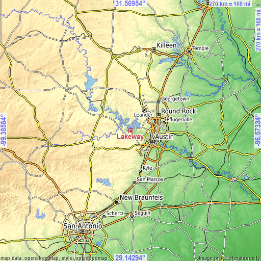
| \ | Map #1 | Map #2 | Topo.Map |
| Scale [m] | 168..364 m | 137..393 m | × |
| Scale [ft] | 551..1194 ft | 449..1289 ft | × |
| Average | 250.7 m = 823 ft | 259 m = 850 ft | × |
| Width | 8.43 km = 5.2 mi | 16.86 km = 10.5 mi | 269.8 km = 167.6 mi |
| Height | 8.43 km = 5.2 mi | 16.86 km = 10.5 mi | 269.8 km = 167.6 mi |
| ↑Max Latitude | 30.40168° | 30.439576° | 31.56954° |
| Latitude at center | 30.36377° | 30.36377° | 30.36377° |
| ↓Min Latitude | 30.325845° | 30.287906° | 29.14294° |
| ← Min Longitude | -98.023535° | -98.067481° | -99.38584° |
| Longitude center | -97.97959° | -97.97959° | -97.97959° |
| →Max Longitude | -97.935645° | -97.891699° | -96.57334° |
Nearby cities:
Cities around Lakeway sort by population:
• Jollyville elevation 291 m
21.5 km,  65°
65°
• Anderson Mill 296 m
19.5 km,  58°
58°
• Lago Vista 245 m
10.8 km,  355°
355°
• Bee Cave 284 m
7 km,  151°
151°
• Lost Creek 257 m
15 km,  120°
120°
• West Lake Hills 252 m
18.6 km,  113°
113°
• Barton Creek 252 m
13.7 km,  129°
129°
• Hudson Bend 237 m
7.7 km,  39°
39°
• The Hills 259 m
1.8 km,  196°
196°
• Jonestown 253 m
15.6 km,  20°
20°
• Rollingwood 203 m
20.5 km, 118°
• Briarcliff 236 m
7.9 km,  307°
307°
Multilingual:
 En español:
Lakeway elevación 228 m.
 En France:
Lakeway élévation 228 m.


Sources and notes:
- [note 1] Map square and city borders are not equal. Map elevation data is calculated only from area inside that square.
- [src 1] Elevation data from geonames database provided with same terms of usage.
- [src 2] The elevation map of Lakeway is generated using elevation data from NASA's 3 arcsec (90m) resolution SRTM data.
- [src 3] Base (background) map © OpenStreetMap contributors tiles are generated by Geofabrik and OpenTopoMap.
Copyright & License:
This Lakeway Elevation Map is licensed under CC BY-SA. You may reuse any part from this page, if you give a proper credit by linking to this URL:
 More info on terms of use page.