Heath elevation
Heath (Texas, Rockwall County), United States elevation is 157 meters and Heath elevation in feet is 515 ft above sea level [src 1]. Heath is a populated place (feature code) with elevation that is 122 meters (400 ft) smaller than average city elevation in United States.
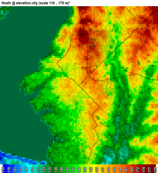
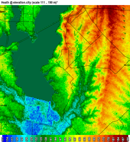
Below is the Elevation map of Heath, which displays elevation range with different colors. Scale of the first map is from 116 to 179 m (381 to 587 ft) with average elevation of 146.2 meters (=480 ft) [note 1]
These maps also provides idea of topography and contour of this city, they are displayed at different zoom levels. More info about maps, scale and edge coordinates you can find below images.
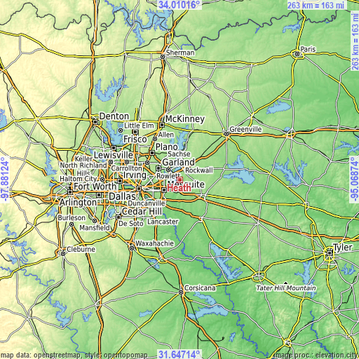
| \ | Map #1 | Map #2 | Topo.Map |
| Scale [m] | 116..179 m | 111..190 m | × |
| Scale [ft] | 381..587 ft | 364..623 ft | × |
| Average | 146.2 m = 480 ft | 148.6 m = 488 ft | × |
| Width | 8.21 km = 5.1 mi | 16.42 km = 10.2 mi | 262.7 km = 163.2 mi |
| Height | 8.21 km = 5.1 mi | 16.42 km = 10.2 mi | 262.7 km = 163.2 mi |
| ↑Max Latitude | 32.873426° | 32.910327° | 34.01016° |
| Latitude at center | 32.83651° | 32.83651° | 32.83651° |
| ↓Min Latitude | 32.799579° | 32.762632° | 31.64714° |
| ← Min Longitude | -96.518935° | -96.562881° | -97.88124° |
| Longitude center | -96.47499° | -96.47499° | -96.47499° |
| →Max Longitude | -96.431045° | -96.387099° | -95.06874° |
Nearby cities:
Cities around Heath sort by population:
• Garland elevation 174 m
17.5 km,  298°
298°
• Mesquite 155 m
14 km,  236°
236°
• Rowlett 155 m
11.1 km,  311°
311°
• Rockwall 184 m
10.6 km,  7°
7°
• Balch Springs 159 m
18.3 km,  229°
229°
• Sachse 169 m
19.2 km,  324°
324°
• Forney 149 m
9.8 km,  178°
178°
• Fate 183 m
14.6 km,  36°
36°
• Sunnyvale 152 m
9.2 km, 240°
• Travis Ranch 147 m
3.7 km, 177°
• McLendon-Chisholm 158 m
8.8 km,  85°
85°
• Talty 138 m
19 km,  153°
153°
Multilingual:
 En español:
Heath elevación 157 m.
 En France:
Heath élévation 157 m.


Sources and notes:
- [note 1] Map square and city borders are not equal. Map elevation data is calculated only from area inside that square.
- [src 1] Elevation data from geonames database provided with same terms of usage.
- [src 2] The elevation map of Heath is generated using elevation data from NASA's 3 arcsec (90m) resolution SRTM data.
- [src 3] Base (background) map © OpenStreetMap contributors tiles are generated by Geofabrik and OpenTopoMap.
Copyright & License:
This Heath Elevation Map is licensed under CC BY-SA. You may reuse any part from this page, if you give a proper credit by linking to this URL:
 More info on terms of use page.