Godley elevation
Godley (Texas, Johnson County), United States elevation is 287 meters and Godley elevation in feet is 942 ft above sea level [src 1]. Godley is a populated place (feature code) with elevation that is 8 meters (26 ft) bigger than average city elevation in United States.
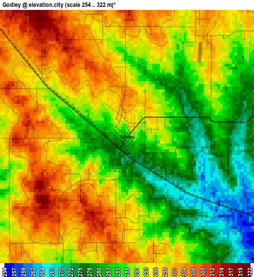
Below is the Elevation map of Godley, which displays elevation range with different colors. Scale of the first map is from 254 to 322 m (833 to 1056 ft) with average elevation of 291.2 meters (=955 ft) [note 1]
These maps also provides idea of topography and contour of this city, they are displayed at different zoom levels. More info about maps, scale and edge coordinates you can find below images.
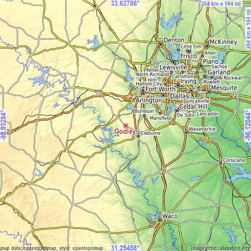
| \ | Map #1 | Topo.Map |
| Scale [m] | 254..322 m | × |
| Scale [ft] | 833..1056 ft | × |
| Average | 291.2 m = 955 ft | × |
| Width | 8.25 km = 5.1 mi | 263.9 km = 164 mi |
| Height | 8.25 km = 5.1 mi | 263.9 km = 164 mi |
| ↑Max Latitude | 32.486106° | 33.62786° |
| Latitude at center | 32.44903° | 32.44903° |
| ↓Min Latitude | 32.411938° | 31.25458° |
| ← Min Longitude | -97.570635° | -98.93294° |
| Longitude center | -97.52669° | -97.52669° |
| →Max Longitude | -97.482745° | -96.12044° |
Nearby cities:
Cities around Godley sort by population:
• Burleson elevation 220 m
21.9 km,  61°
61°
• Cleburne 240 m
17.3 km,  130°
130°
• Benbrook 213 m
25.7 km,  13°
13°
• Crowley 241 m
21.1 km,  46°
46°
• Granbury 228 m
25.1 km,  268°
268°
• Keene 279 m
19.9 km,  106°
106°
• Joshua 289 m
13.1 km,  83°
83°
• Pecan Plantation 224 m
17.1 km,  234°
234°
• Aledo 273 m
28.4 km,  345°
345°
• Edgecliff Village 214 m
28.9 km,  36°
36°
• DeCordova 223 m
15.9 km,  262°
262°
• Oak Trail Shores 253 m
29.2 km,  278°
278°
Multilingual:
 En español:
Godley elevación 287 m.
 En France:
Godley élévation 287 m.


Sources and notes:
- [note 1] Map square and city borders are not equal. Map elevation data is calculated only from area inside that square.
- [src 1] Elevation data from geonames database provided with same terms of usage.
- [src 2] The elevation map of Godley is generated using elevation data from NASA's 3 arcsec (90m) resolution SRTM data.
- [src 3] Base (background) map © OpenStreetMap contributors tiles are generated by Geofabrik and OpenTopoMap.
Copyright & License:
This Godley Elevation Map is licensed under CC BY-SA. You may reuse any part from this page, if you give a proper credit by linking to this URL:
 More info on terms of use page.