DeCordova elevation
DeCordova (Texas, Hood County), United States elevation is 223 meters and DeCordova elevation in feet is 732 ft above sea level [src 1]. DeCordova is a populated place (feature code) with elevation that is 56 meters (184 ft) smaller than average city elevation in United States.
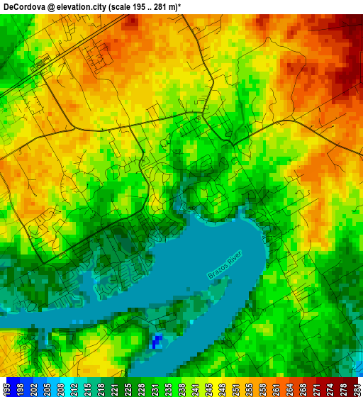
Below is the Elevation map of DeCordova, which displays elevation range with different colors. Scale of the first map is from 195 to 281 m (640 to 922 ft) with average elevation of 237.8 meters (=780 ft) [note 1]
These maps also provides idea of topography and contour of this city, they are displayed at different zoom levels. More info about maps, scale and edge coordinates you can find below images.
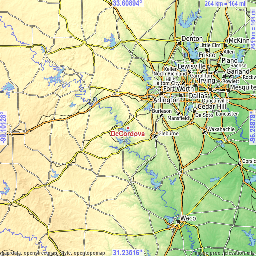
| \ | Map #1 | Topo.Map |
| Scale [m] | 195..281 m | × |
| Scale [ft] | 640..922 ft | × |
| Average | 237.8 m = 780 ft | × |
| Width | 8.25 km = 5.1 mi | 263.9 km = 164 mi |
| Height | 8.25 km = 5.1 mi | 263.9 km = 164 mi |
| ↑Max Latitude | 32.466944° | 33.60894° |
| Latitude at center | 32.42986° | 32.42986° |
| ↓Min Latitude | 32.39276° | 31.23516° |
| ← Min Longitude | -97.738975° | -99.10128° |
| Longitude center | -97.69503° | -97.69503° |
| →Max Longitude | -97.651085° | -96.28878° |
Nearby cities:
Cities around DeCordova sort by population:
• Cleburne elevation 240 m
30.4 km,  107°
107°
• Benbrook 213 m
34.9 km,  39°
39°
• Granbury 228 m
9.4 km,  278°
278°
• Keene 279 m
35 km,  96°
96°
• Joshua 289 m
29 km,  83°
83°
• Pecan Plantation 224 m
7.9 km,  166°
166°
• Aledo 273 m
30.8 km,  16°
16°
• Oak Trail Shores 253 m
14.6 km,  296°
296°
• Glen Rose 191 m
22.4 km,  194°
194°
• Western Lake 243 m
24.1 km,  333°
333°
• Annetta 274 m
31.1 km,  3°
3°
• Godley 287 m
15.9 km, 82°
Multilingual:
 En español:
DeCordova elevación 223 m.
 En France:
DeCordova élévation 223 m.
 Auf Deutsch:
DeCordova höhe über dem Meeresspiegel ist 223 m.

Sources and notes:
- [note 1] Map square and city borders are not equal. Map elevation data is calculated only from area inside that square.
- [src 1] Elevation data from geonames database provided with same terms of usage.
- [src 2] The elevation map of DeCordova is generated using elevation data from NASA's 3 arcsec (90m) resolution SRTM data.
- [src 3] Base (background) map © OpenStreetMap contributors tiles are generated by Geofabrik and OpenTopoMap.
Copyright & License:
This DeCordova Elevation Map is licensed under CC BY-SA. You may reuse any part from this page, if you give a proper credit by linking to this URL:
 More info on terms of use page.